 I am a Technical Director at JBA Consulting, based at Saltaire in West Yorkshire, specialising in Natural Flood Management (NFM) and Working with Natural Processes (WwNP). I have 30 years’ experience of applied environmental research and consultancy in the areas of rural land management and drainage, surface water pollution (pesticides, nutrients, pathogens) and wetland restoration. I have led a number of multi-disciplinary R&D and consultancy projects for clients into the impact of rural and agricultural land management activities on the soil and water environment. This included two major Defra funded national R&D studies (published in 2004 and 2007) that examined how rural land use and land management influence runoff generation, flooding dynamics and flood risk. Both these studies explored the fundamental hydrological processes taking place in catchments and what controls and/or affects them, which now forms a vital element in the assessment of NFM opportunities and the development of NFM delivery initiatives.
Over the last 15 years I have worked on over 30 NFM projects throughout the UK for numerous clients, ranging from strategic level NFM opportunity assessment, modelling multiple distributed NFM measures across catchments, developing concept designs for NFM schemes, and contributing to stakeholder NFM engagement and training events. I have led the JBA contribution to the Holnicote Multi-Objective Flood Management Demonstration Project in Somerset since its commencement in 2009. I also led the consortium delivery team that assisted in the development of the NFM Handbook for SEPA (2015); and the consortium that worked with the EA to develop the national evidence base on WwNP (2017).
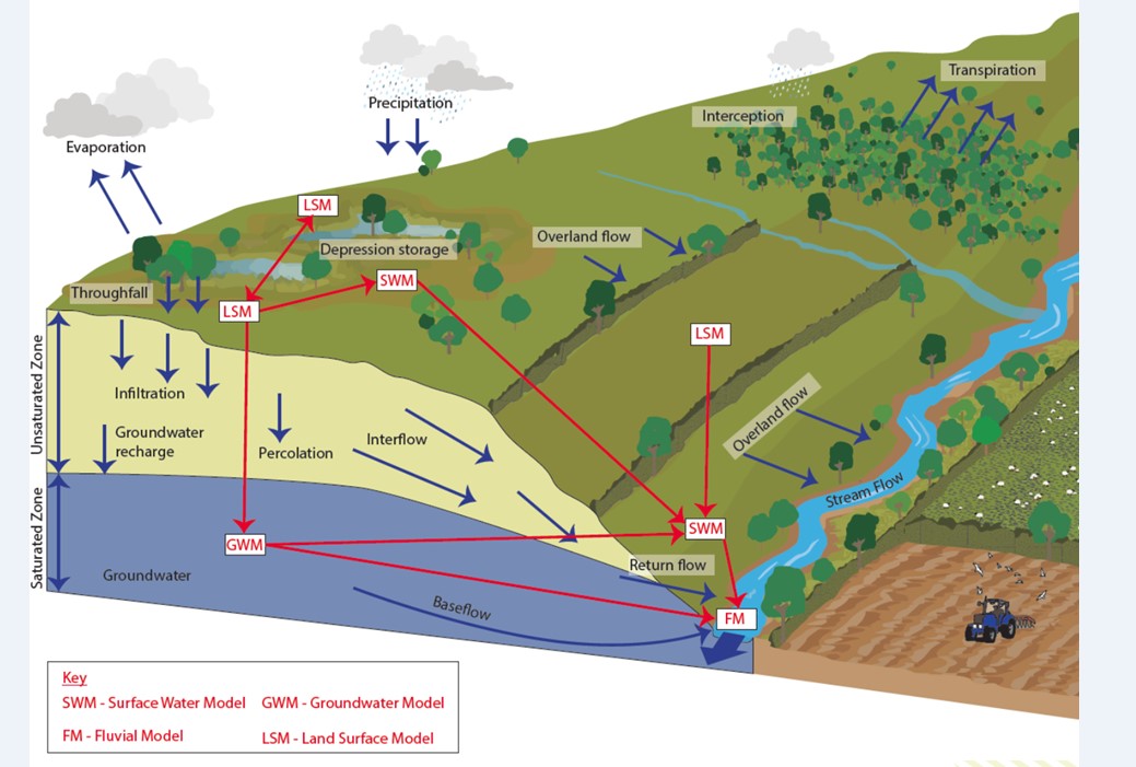
For the LANDWISE project, I lead Work Package 4, which is applying a linked modelling approach to explore the effectiveness of a number of land-based NFM measures implemented across a range of scales and catchment characteristics in lowland Britain, with a particular emphasis on more permeable geologies. The NFM measures under consideration include: land and soil management, runoff pathway management, woodland creation and floodplain management. The challenges of this work package will be to model how the characteristics of the various NFM measures influence different components of the hydrological cycle, and especially the water flow pathways from the moment that incident rainfall hits the landscape surface, flows over or into the soil, percolates into underlying groundwater systems with some eventually re-emerging, possibly weeks/months later, into the watercourses as baseflow or return flow contributions.
The most significant challenge for the WP4 researchers (JBA, University of Reading and the British Geological Survey) will be the linking of datasets and modelling outputs from 4 components of the hydrological cycle, namely: land surface interactions, surface runoff, interflow and groundwater movement, and fluvial (river) flows. The modelling work will be informed by a wide variety of national datasets and other information sources, together with more localised datasets from across the West Thames Basin being generated by the wider LANDWISE project team, from WP1 (Local Knowledge from Stakeholders), WP2 (Soils) and WP3 (Remote Sensing).

WP4 Modelling schematic: How different models can be linked to represent different components of the hydrological cycle in a rural catchment context.