In the Philippines, at the University of Santo Tomas, we are now well underway with the first stage of our mapping, which is data collection. Our site of Santa Rosa is divided into 18 political districts called barangays. We have combined social research methods (questionnaires and focus group discussions) with desktop analysis of documents such as the land use plan and development plan for the area.
Early in the project, we conducted field reconnaissance surveys in to understand the topography, geology and traffic volume, environmental use (such as open spaces and greenery), and social and economic land use (construction, agricultural trends, industrial and commercial activities). Socio-cultural assets, activities of the informal sector of the economy, types of small businesses, and existing routes were also noted. We also made preliminary investigations into site conditions with infrastructure availability/accessibility (or lack of it) and types of housing (as proxy for income level).
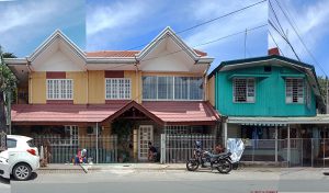
We have also used visual methods. Streets were documented though photography in the 18 barangays. These revealed variations in building forms and streetscapes. Linear street scale panoramas were prepared for each barangay by stitching photos taken from multiple viewpoints following a linear path along a specific street. Alongside these street views, vehicular and pedestrian routes were traced with the help of the participants of the focus groups. The participants were given a map where they could trace their travel routes from home to work.
The Socio-economic data and environmental profile of the 18 barangays (sub-units or lower administrative units) of the city were collected and analysed in order to provide a basis for the selection of five (5) barangays which will be studied in greater detail. These were chosen according to the following criteria:
- Geographical location of the barangay in relation to the Laguna Lake,
- Population and land area ratio,
- Historical significance,
- Economic profile;
Based on the field survey and data provided by the city, the barangays can be characterized as described below:
- Barangay Aplaya located along the Laguna lake shore making it the very susceptible to the risks of flooding. The economic realities present in the Barangay such as those related to fisheries make it an interesting subject of this study.
- Barangay Kanluran, even though is one of the smallest barangays of Santa Rosa in population and land area, it can be considered the most historical since it partly belongs to the población (the administrative and socio-cultural center of the city since its founding) of the city. Kanluran is home to the ancestral houses of the Zavallas, Tiongcos and Perlas’ to name a few. It is also where the old City Plaza is located in front of the Parish Church of Santa Rosa de Lima, the patroness to whom the city was dedicated.
- Barangay Dila, a sprawling urban community along the Old National Highway filled with residential enclaves. It is classified as Heavy Commercial based on Land Classification and is home to almost 9% of the total population of Sta. Rosa, the second most populated Barangay of the City.
- Barangay Balibago may be considered the center of commerce of Sta. Rosa, being connected to the South Luzon Express Way. It is also home to the largest Leisure Park of South Luzon, the Enchanted Kingdom and one of the biggest malls in the city, SM Sta. Rosa.
- Barangay Sto. Domingo, although has a small population is one of the largest barangays in terms of land area and is identified as one of the heavy industrial mixed-use areas of Sta. Rosa based on land classification and considered as Tourism and Low Density Residential Mixed-Use area based on Land Use. It lies in the western fringe of the city with new residential developments. It is also where the historical Spanish Cuartel de Santo Domingo is located.