Boxing Day 2020 was so blustery that more than half of the UK’s daily electricity was met by wind power for the first time. Just over a week later, the wind died as a cold snap kicked off 2021 with sub-zero temperatures and scattered snow. With most people stuck at home due to a new national lockdown, demand for heating and electricity rose just as the conditions for generating renewable energy abated.
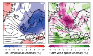
Cold snaps with very light winds tend to cause the most stress to the UK’s national grid. These weather systems usually form when regions of high pressure engulf the atmosphere around the UK, causing temperatures to plummet as cold weather arrives from Scandinavia and Russia. The prolonged cold weather associated with these events is sometimes dubbed “Beast from the East” by the British media, after similar atmospheric conditions brought snowstorms and travel chaos in February 2018. This time around, the UK’s large offshore wind farms in the North Sea were among the biggest losers.

The low winds and high cloud cover reduced wind and solar power generation, forcing the National Grid – the UK’s power system operator – to call for suppliers to generate extra electricity or face potential blackouts. In the past, demand spikes and tight supply margins would be solved by ramping up generation from fossil fuel power plants, which are effectively on standby. But the UK’s power grid increasingly relies on renewable energy sources – and the government plans to quadruple offshore wind generation by 2030.
The UK is connected to France, Northern Ireland, the Republic of Ireland and the Netherlands by large power cables that allow electricity to flow between them. But the UK cannot rely on importing energy, as the cold and still conditions created during these atmospheric events also tend to affect neighbouring countries. Instead, maintaining a continuous supply of largely renewable energy during difficult winter periods will mean improving our weather forecasting ability so that potential energy shortages can be predicted weeks in advance.

That’s where my research comes in.
Weather forecasts for the energy sector
We tend to check the forecast to find out what the weather will do over the next few days. But in the last few years, meteorologists have made rapid progress in forecasting the weather at longer timescales – from one week to several months ahead.
When creating a weather forecast for these extended periods, meteorologists tend to focus on predicting large-scale weather patterns, as this is where the relevant models still have some skill. Forecasters can then infer the average relationship between these weather patterns and the surface weather conditions that usually result based on past events.
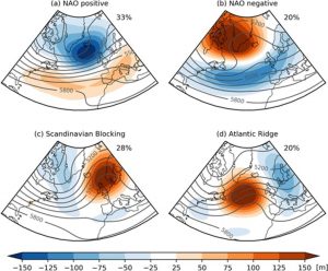
One way to define weather patterns is to train a computer to spot similarities between large-scale weather conditions and sort them into a small number of clusters, with all the days in each cluster having similar weather.

But these traditionally defined weather patterns don’t strongly influence the rates of wind and solar power generation over Europe. That’s because they’re based on data drawn from large geographic regions, most of which are over the ocean and don’t adequately capture finer scale conditions in regions where most people live. This makes forecasting energy demand very difficult.
My colleagues and I at the University of Reading have developed a new method that classifies components of the European energy system that depend on the weather, such as energy demand and wind and solar power generation, into patterns. These different patterns are defined using national daily energy data, rather than the daily weather data typically used. Using energy data to define weather patterns focuses their impact over land, and could show which weather conditions coincide with low energy demand in multiple countries or when countries are more likely to experience an energy demand peak.
Recent work using state-of-the-art weather forecast models has found traditional weather patterns and wind energy generation and national demand can be predicted for several weeks in the future using this approach. Accurate forecasts at this range would allow energy system operators to take early action if there is the chance of an extreme event, helping avoid energy price spikes and ultimately making sure that the lights stay on, whatever the weather.
Dr Hannah Bloomfield is a Research Scientist in the National Centre for Atmospheric Science.
This article is republished from The Conversation under a Creative Commons license.
