Oliver Froome-Lewis presented a paper, ‘Drawing Maps: Systems and Disruptions‘ at Disegno 2018, at the Faculty of Architecture, Tournai, Belgium.
In his paper for Disegno 2018 (18-20th January), Froome-Lewis considers the map as systematiser, disruptor, metaphor and reality system and consider the way that actions play out, never quite producing the anticipated behaviours. Drawing a map simultaneously organises two surfaces, the content on the paper and the corresponding territory on the ground that it seeks to represent. The map offers information about what might be encountered which is then augmented or confounded during the resulting physical journey. Can propositional maps (i.e. maps with behavioural intent), produce a new, free flowing territory that can be travelled in the imagination and in reality or in both concurrently, creating possibilities for new kinds of interaction in the city and stimulating new co-dependencies between the imagination, expectation and experience? In ‘The Practice of Everyday Life’, de Certeau proposes a useful distinction between the organisational strategies that emerge from institutions and structures of power, and the consumers who use a variety of subversions and manipulative tactics on the ground. A map, created as a dispositif, then becomes disordered when performed by the consumer, as a consequence of tactical (mis)interpretations.
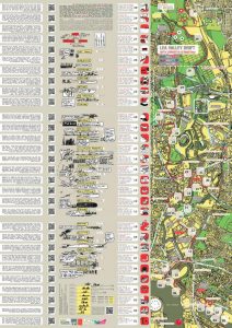
In 2013, Froome-Lewis published and distributed eight thousand copies of two maps, designed for London Legacy as part of their ‘Emerging East’ initiative, to connect communities surrounding the Lee Valley and the Olympic Park in East London. A series of experimental traversals of the territory informed the creation of the maps. He has since been framing this work, and other practices carried out in the field, in theory so as to develop the potency of such maps. Where the map can be regarded as a discursive choreography, real and virtual, for performing the city. Selecting and curating map content creates new realities.