Our First MESA Blog Post
What’s been happing in Reading?
Welcome to the very first MESA blog post! We will use this blog to record ongoing activities of the project. My name is Eli and together with Flora and Lorraine, we are the Reading MESA team. In due course I will introduce the team from Santo Tomas in Manila in the Philippines and the work that they are doing. This first post will discuss our initial activities and thoughts here in Reading.
The first steps that we took were aimed at getting a better understanding of the different types of research currently being conducted through maps and mapping, so that we could begin to think about how the work we are doing will relate to, and build upon, current trends. Across disciplines there is a growing interest in using mapping as a way of reflecting upon and researching spatial issues. These issues range, not least, from the from the social to the environmental and cover scales from the statistical to the personal.
As soon as I started looking for maps I found them everywhere. At one level the abundance of different maps and mapping techniques was overwhelming, but at another it was inspiring, since it demonstrates that there is no single ‘correct’ way that we have to do things. This leaves great scope for creatively developing new ideas and approaches.
One interesting outcome of the initial study into research being conducted through mapping was the distinct scarcity of architects doing this type of research, as opposed to the many geographers and social scientists. This led us to the idea that we would focus our attention on methodologies for mapping that could be useful for architect researchers and practitioners and test these methodologies in context at our site in Reading.
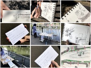
The site we have chosen is in central Reading along a stretch of the Kennet and Avon Canal near Orts Road. Over the summer, I got help from a couple of student interns who conducted fieldwork with me. We used our smartphones to gather geolocated photographs that we mapped through software called Mapillary. Following this, we engaged with the public along the canal by setting up duck feeding stations with healthy duck food such as peas and oats. We asked people what they valued most locally, as the first steps toward making a value map.
As the project progresses, lots of different methodologies will be tested and developed, no doubt some will be more successful than others, but the outcome should be a really useful resource for architects who want to map.