Smart urban flood prediction using data assimilation
Urban floods are very difficult to predict due to the complexity of the terrain e.g., buildings, underground sewer systems etc. To model water flow in a city, a very high spatial and temporal resolution is needed which is very computationally expensive. However, urban flooding is associated with great financial and human cost. Hence it is very important having accurate and timely predictions of urban floods.The good news is that there is a growing amount of data available about our cities, such as CCTV images of rivers, traffic and streets, citizen-sourced smartphone images, as well as scientific river gauge data and satellite images.
Data assimilation (DA) is a technique that combines model forecasts and observational data to improve forecasts of urban flooding. To apply data assimilation to urban flooding prediction we need to take into account:
- nonlinearity of the model (short spatial and temporal timescales);
- nonlinearity of observations (satellite images, CCTV and smartphone images);
- a large number of uncertain model parameters;
- uncertain model boundary conditions such as inflows.
Our aim is to develop new, flexible DA techniques that can be applied at any location, assimilating new sources of observation information for state estimation, and to further develop these techniques for use in flood control and mitigation.
You can read these blog posts to find out more about our research in detail
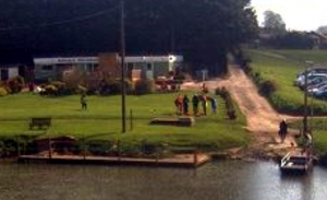
DARE first field trip to visit river cameras near Tewkesbury |
|
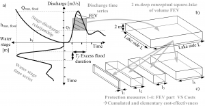
Controlling and mitigating urban flooding with DAby Prof Onno Bokhove and Tom Kent, PDRA, University of Leeds
|
 |