
“These ruts in the ground between geoglyphs were once well-kept roads”
Sanna Saunaluoma
In 1887, a party of 35 people led by colonel Antonio Rodrigues Pereira Labre (1827–1899) traveled 200 kilometers (km) on foot on an expedition to plan overland rubber transport routes from the Madre de Dios River in Bolivia to the Acre River in present-day Brazil. But the expedition also provided an important account about the indigenous peoples living in this Amazon region, then and in the more distant past. “From this abandoned maloca, we headed to Canamary, passing through several ancient, abandoned villages and many crossings where several roads intersected each other in all directions,” wrote Labre in his report, published in 1888 in Revista da Sociedade de Geographia do Rio de Janeiro. “The men report having walked for 20 days straight along existing roads,” notes archaeologist Eduardo Góes Neves, of the University of São Paulo’s Museum of Archaeology and Ethnology (MAE-USP).
Around 120 years after Labre’s expedition, a transmission line tower was erected on one of these ancient indigenous roads in eastern Acre, which had gone undetected in the preceding environmental impact assessment. “The road wasn’t recognized because it was common wisdom that indigenous peoples never built roads,” explains archaeologist Laura Furquim, a doctoral student in Neves’s group. In 2014, the USP team was engaged by the National Institute for Historical and Artistic Heritage (IPHAN) to prepare a report on the deteriorating structures. “We set up a field school now attended by students from Acre, Rondônia, and São Paulo,” says Neves. Their findings, which they reported in an article published in November in Latin American Antiquity, describe a pre-Columbian network of villages interconnected by well-maintained roads (see Pesquisa FAPESP issue no. 267).
The study, led by Finnish archaeologist Sanna Saunaluoma during a postdoctoral internship in Brazil in 2015, is centered around a cluster of 18 archaeological villages with large circular or ellipse-shaped central plazas about 2 to 3 hectares (ha) in diameter. Encircling the plazas are 15 to 25 mounds about 2.5 meters (m) in height and between 10 and 25 m in maximum basal length. And radiating from the villages are sunken paths bounded by elongated mounds—there are no stones available at the site—leading to nearby watercourses and other villages. When seen from above, these mounds resemble the rays of the sun.
Using unmanned aerial vehicles (UAVS), the researchers were able to detect prominent patterning which they reproduced in hillshaded 3D models. Radiocarbon measurements showed that the structures had been built around 1300 to 1600 AD. The researchers soon found that the road network was much more extensive than initially thought.
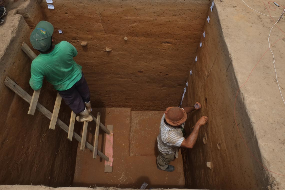
Eduardo Góes Neves / USP An excavation at the Sol de Campinas site: cookware and plant remains provide evidence of when the area was inhabited and the ways of life of early inhabitantsEduardo Góes Neves / USP
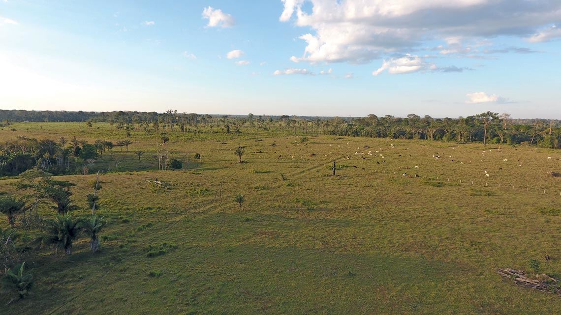
Their concern now is in gaining as much insight into these ancient cultures as possible while traces of them still remain. “The region is at the deforestation frontier, with many areas being cleared for farming,” says Neves. “Farmers often deliberately destroy archaeological sites so they won’t be restricted from using the land for agriculture.” This happened at Sol de Campinas, one of the major sites being investigated by the USP group. “Half of the mounds were bulldozed, and recently the Fazenda Crichá geoglyph was also destroyed.”
The site, now a field sparsely populated by bamboo stands, was a dense jungle 50 years ago. Archaeological remains in the area provide evidence of pre-Columbian domestication of edible plants (see Pesquisa FAPESP issue no. 253). Neves pictures a villagescape with pathways lined with trees and agroforestry systems. “We traveled down a good and well-kept road; we passed through three villages with well-built houses and cultivated fields,” wrote Labre in his report, which archaeologist Cliverson Pessoa, a doctoral student in Neves’s group, explored in a 2017 paper in Tellus.
And while available research data is insufficient to paint a detailed picture of what pre-Columbian agriculture may have been like, Laura Furquim, who has worked in the region since 2014, is investigating the use of edible plants by early inhabitants at Sol de Campinas, in the municipality of Senador Guiomard. Using archaeobotanical methods, she is analyzing the remains of seeds and other plant matter used by the area’s ancient inhabitants. “We found an abundance of maize kernels,” she says, suggesting intensive consumption and cultivation. She is also analyzing trace plant matter found in cookware—such as when rice is overcooked and sticks to the bottom of the pan. “By examining starchy plant matter under a microscope, we can identify the different types of plants, such as tubers,” she explains. The damage visible on some kernels can provide clues into the methods used to process them. “We found evidence that the maize was either roasted or fermented.” Her study, which is still ongoing, is attempting to reconstruct the eating habits of these indigenous groups.
She believes the area was abandoned in the eighteenth century following the arrival of European colonists in search of wealth from the rubber trade, with the local indigenous peoples either migrating away or becoming slaves. Ancient agroforestry systems consisted of a combination of cultivated plants like corn, beans, and fruits—such as passion fruit—in the central village plazas, encircled by domesticated trees bearing edible fruits and nuts, such as açaí and tucumã. Today, these biodiverse practices have been replaced by large-scale monoculture of transgenic soy and maize, as well as pastures for cattle—such as on the property containing the Sol de Campinas site.
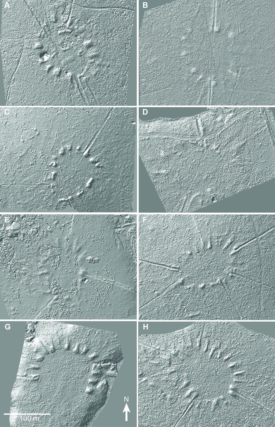
Sanna Saunaluoma & Justin Moat 3D models reproducing aerial imagery show the layout of the mound villagesSanna Saunaluoma & Justin Moat
Mound sites are part of a broader category of vestiges of human occupation, known as geoglyphs—changes made to the terrain by human inhabitants. More than 500 have been found in the western portion of the Amazon over the past 20 years, after paleontologist Alceu Ranzi, of the Federal University of Acre, first spotted a huge circle from the window of an airplane flying to Rio Branco, northern Brazil. Ranzi, who had received training in geography, timed how long it took to fly from the spot to a known reference point. He then borrowed a plane and flew back to the site to investigate and take photographs. He found it precisely where he estimated it to be, deep in the jungle. “When our eyes have been trained, we soon begin to spot geoglyphs right and left,” says Ranzi.
He immediately knew the geometric shape beneath the jungle canopy could be a significant discovery, and reported what he had seen to archaeologist Denise Schaan (1962–2018), who started an investigation of the area, then a virgin territory for archaeologists. “It was far from what were then the archaeological hotspots—Marajó and Cusco, Peru,” she recalls.
Today this has changed. Schaan partnered with Finnish researchers led by archaeologist Martti Pärssinen, and researchers from other countries and from across Brazil—like Neves—were soon attracted to the region, now an archaeological research hub.
Excavations have revealed that geometric geoglyphs in eastern Acre were used not for residential purposes, but as ceremonial arenas where groups living elsewhere assembled. Mound site excavations in Acre and Amazonas suggest that even these older structures may have been connected by roads, as Pärssinen and Ranzi report in a chapter of the book (I)mobilidades na pré-história ((Im)mobility in prehistoric times), published in March 2020. “The oldest radiocarbon sample we obtained at the Tequinho site in Acre was clearly associated with the site’s north road, and was dated at between 63 BC and 124 AD,” Pärssinen wrote in an e-mail. “It is a date very similar to that obtained for the Atlântica site and its roads, which Saunaluoma excavated during her doctoral research—between 200 BC and 20 AD.” Post-publication of the book, they found an even older site elsewhere in the region, dating back to 750 BC.
For Pärssinen, the recent article by Saunaluoma and Neves sheds new light on more recent geoglyphs, from a period when some geometric structures still retained their purely ceremonial status. “It seems to me that the network of geometric geoglyphs they describe, with its sophisticated road system, was inhabited by a multi-ethnic civilization that had a common worldview and shared common cultural traits,” he concludes.
Archaeological research can also reveal links between human settlements, their land-use practices, and climate change. In a paper published in December in Antiquity, Pärssinen, Ranzi, and other colleagues report finding no evidence of major changes in rainfall patterns around 10,000 years ago, when the earliest human settlements were formed away from major rivers, in the interfluves. Excavations at the Severino Calazans geoglyph site in Acre showed that about 4,000 years ago its early inhabitants used controlled burning to manage the landscape, much as the indigenous peoples in the region do today. These practices, rather than climate change, are thought to be responsible for the savannah-like patches that formed there in that period.
One of the difficulties in studying geoglyphs is that they are typically found in already-deforested areas. When covered by the forest canopy, they are virtually invisible. But this has changed with the advent of LIDAR (Light Detection and Ranging), a technology that has revolutionized archaeology in the last decade. From an aerial vehicle, a LIDAR system emits 5,000 pulses of infrared rays per minute, and the time taken for the pulses to hit the surface and return to the sensor provides a measure of distance. In the Amazon, most of the rays are unable to penetrate the dense canopy. But the few that reach the ground are sufficient to generate a detailed rendition of the relief as if the forest were not there.
To test the technology, in 2018 a research team led by José Iriarte from the University of Exeter, UK, in collaboration with Ranzi and others, conducted a three-transect survey in Acre using a LIDAR system integrated into a helicopter. They reported the results in 2020 in the Journal of Computer Applications in Archaeology. They were able to accurately model the dimensions and relief of the mound sites and roads much faster than would be possible with traditional topographic methods. The main roads were between 3 and 6 m wide and had higher banks than secondary roads.
The researchers found mound-like geoglyphs beneath the forest, overlapping structures, and roads connecting different villages. “LIDAR lets researchers see what the naked eye cannot,” says Ranzi.
In a larger-scale study, Chris Fisher from Colorado State University hopes to map the entire Amazon using LIDAR in a collaboration with Neves. He is starting in the Amazon mainly because of the imminent threat of deforestation and destruction of archaeological sites by current human activities, in a region rich in the remains of ancient civilizations. “In 45 minutes, I can capture data that it would take decades to collect on foot,” says Fisher.
Another advantage of LIDAR is that it avoids the destruction of archaeological records. Setting up an archaeological dig site requires access: clearings for helicopters, trails, and roads. All of this damages the terrain, which can lead to erosion and loss of archaeological remains. With LIDAR technology, archaeologists can excavate only at selected points.
Neves believes that, when fully mapped, the geoglyphs will confirm that a large population lived in remote areas of the Amazon well before the arrival of the Europeans. As Labre reported toward the end of the eighteenth century: “From the places I visited and what I heard from the natives, I conclude that along the Curykethê, Huaquery, and Entimary rivers, and along their tributaries, there live assembled together with a great many savages, especially judging from the many roads, paths, and abandoned huts that I have seen along the way.”
This work first appeared on Pesquisa FAPESP under a CC-BY-NC-ND 4.0 license. Read the original here.


