Samantha Broadmeadow from Forest Research and Landwise-NFM talks about mapping Natural Flood Management opportunity from soil data: comparing technical and farmer knowledge

Samantha has worked for Forest Research for 23 years. She explained that in that time mapping, her specialism, has changed: “drastically, and for the better. Initially mapping was quite a niche area, but since user friendly GIS software became available fifteen years ago I have been able to capture and share ideas with others easily and it’s fun!”
Mapping has become an important tool for Forest Research particularly in Samantha’s work on woodland creation She explained: “using GIS tools we can identify where woodland creation can provide additional benefits, or ‘ecosystem services’ and highlight where specific benefits can be maximised, such as biodiversity and flood risk attenuation. This facilitates more focused funding of proposals in an increasingly strategic catchment planning process. Also, mapping provides a communication tool to help engagement with farmers and others who are concerned about how landscapes are managed. This is very much a two-way process as the knowledge and preferences of landowners and local communities need to be factored in to expediate good decision making.” Samantha’s mapping tools have been used by many organisations including Environment Agency, CaBA, farm advisors and Natural England to engage with local partners.
For the Landwise NFM project, Samantha has compared the existing national NFM ‘opportunity maps’ for NFM focused woodland creation, with the results of the Landwise NFM farmer survey on how they manage the soils on their farms and what steps they believe are required to keep it healthy and resilient. She explained “our objective was not to create new opportunity maps, but to explore how accurate and useful the national maps are perceived to be by the farmers, catchment partnerships and government agencies.”
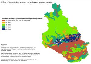
Example map of upper Thames
Samantha pointed out that the research is still to be completed (a paper is in preparation) but that: “…work to date shows a strong overlap between technical and local knowledge; soil types with reported water management challenges were identified as the priority target areas for woodland creation. Initial conclusions indicate that land use, particularly the split between permanent pasture and rotational arable, should be incorporated with soil type in a more detailed land use classification within national opportunity maps.”
She has also used GIS to work with the community NFM preferences from the catchment workshops; to capture and collate the discussion and create future landscape scenarios that will be used by the LANDWISE modelling team to help prioritise and focus their work. She explained: “Cultural and heritage values of the landscape are also important and need to be factored in, to ensure the NFM measures and locations considered are both feasible and acceptable.”
Looking forward, Samantha speculated: “…perhaps there will be scope in the forthcoming Environmental Land Management Scheme (ELMS) to increase incentives for NFM measures in these areas.”
Related NFM webinar recordings:
- Dr Tom Nisbet of Forest Research and Landwise Project: ‘Woodlands and NFM’
- Chris Short, University of Gloucester and Dr Angie Elwin, University of Reading, Landwise Project ‘Integrating local knowledge into NFM work: Insights from lowland catchments in the Landwise project’
Landowners, land managers and public bodies can apply to the England Woodland Creation Offer (EWCO) for support to create new woodland, including through natural colonisation, on areas as small as 1 hectare. A case study here from Elslack Estate (North Yorkshire) explains how woodland can increase land value and generate income, whilst providing environmental benefits such natural flood management and habitat creation.
Contact: samantha.broadmeadow@forestresearch.gov.uk