
Dr Sarah Collins, Dr Majdi Mansour and Dr David Macdonald
Have you ever experienced flooding of a basement or sewer? Or in a valley where there isn’t usually a stream? And did it last for ages? If so, it was most likely groundwater flooding. Groundwater flooding occurs after long periods of wet weather, when the ground becomes completely saturated and the water table reaches the ground surface. It occurs most often in chalk valleys or in river valleys with a thick layer of alluvium or river gravels. The flooding often lasts many months, much longer than flooding caused by a river overflowing its banks.
We (Sarah Collins, Majdi Mansour and David Macdonald) are groundwater scientists at the British Geological Survey. Our research addresses issues, in the UK and internationally, related to the sustainability of water resources, the effects of environmental change on the water cycle and natural hazards in the context of groundwater. Whereas surface water flooding is a relatively mature field of research, groundwater flooding wasn’t even recognised as a phenomenon until the 21st century. We know much more about groundwater flooding now, in part owing to the work of David Macdonald and other colleagues at the British Geological Survey.
Most flood modelling carried out in the UK ignores the contribution of groundwater entirely. The LANDWISE project, however, focusses on lowland permeable catchments, including chalk and limestone, where groundwater is an important part of the water cycle and can be the cause of significant flooding. There are a number of questions we seek to answer within the context of natural flood risk management (NFM) in these catchments: would introducing NFM measures that increase infiltration into the ground make any difference to flooding in catchments where there is very little surface runoff anyway?; could these measures actually increase the risk of groundwater flooding?; could planting trees and increasing evapotranspiration endanger the security of our drinking water supply?; or could NFM both help to reduce flood risk and enhance our groundwater resources?
Our first task on this project was to develop the right modelling tools to allow us to answer these questions. As the contribution of groundwater has traditionally been neglected or highly simplified in flood inundation modelling, we needed to develop our own model. The new model couples a 3D groundwater model of the subsurface with a popular 2D surface water model called LISFLOOD-FP. This coupled model allows us to simulate the flow of groundwater out of the ground where the water table reaches the land surface, and then how it moves overland. We initially tested the model in the Pang and Lambourn catchments, Berkshire, for two historic flooding events, and are now working with our colleagues at the University of Reading and JBA to use the model to explore the effects of NFM in these catchments.
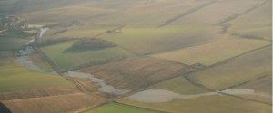
Above: The emergence of groundwater in a chalk valley. © UKCEH[CSL1] , 2003
Contact: sarcol@bgs.ac.uk