Introduction
Group leader Sandy Harrison recently published a manuscript in the journal remote sensing of the environment as part of the LEMONTREE project. The work was led by Sungchan Jeong who is a member of the LEMONTREE team based at Seoul National University. The new research highlights how satellite remote sensing data can be used to improve the accuracy of vegetation index datasets.
The problem
The paper “Persistent global greening over the last four decades using novel long-term vegetation index data with enhanced temporal consistency” focuses on improving the temporal consistency of long-term vegetation index datasets. Advanced Very High-Resolution Radiometer (AVHRR) sensors on satellites produce some of the world’s longest data measurements on land surfaces and have been used to derive vegetation indexes, amongst other products. However, a number of studies have pointed out that there are issues with the AVHRR derived datasets including temporal inconsistencies, orbital shifting and incomplete harmonization with other satellite products.
Methods and Results
This study addressed residual temporal inconsistency in the LTDR V5 dataset through a three-step post-processing, which includes cross sensor-calibration between AVHRR sensors, orbital drifting correction among AVHRR sensors, and a machine-learning based harmonization with MODIS.
Each different processing level of spectral reflectance and vegetation index were comprehensively evaluated across the pseudo-invariant calibration sites (PICS). After a three-step post-processing was applied, the remaining temporal inconsistencies in the long-term datasets were substantially reduced.
The refined long-term normalized difference vegetation index (NDVI) and near-infrared reflectance of vegetation (NIRv) datasets showed a persistent global greening trend over the last four decades. This is in contrast with previous studies which have demonstrated a decline in global greening since 2000.
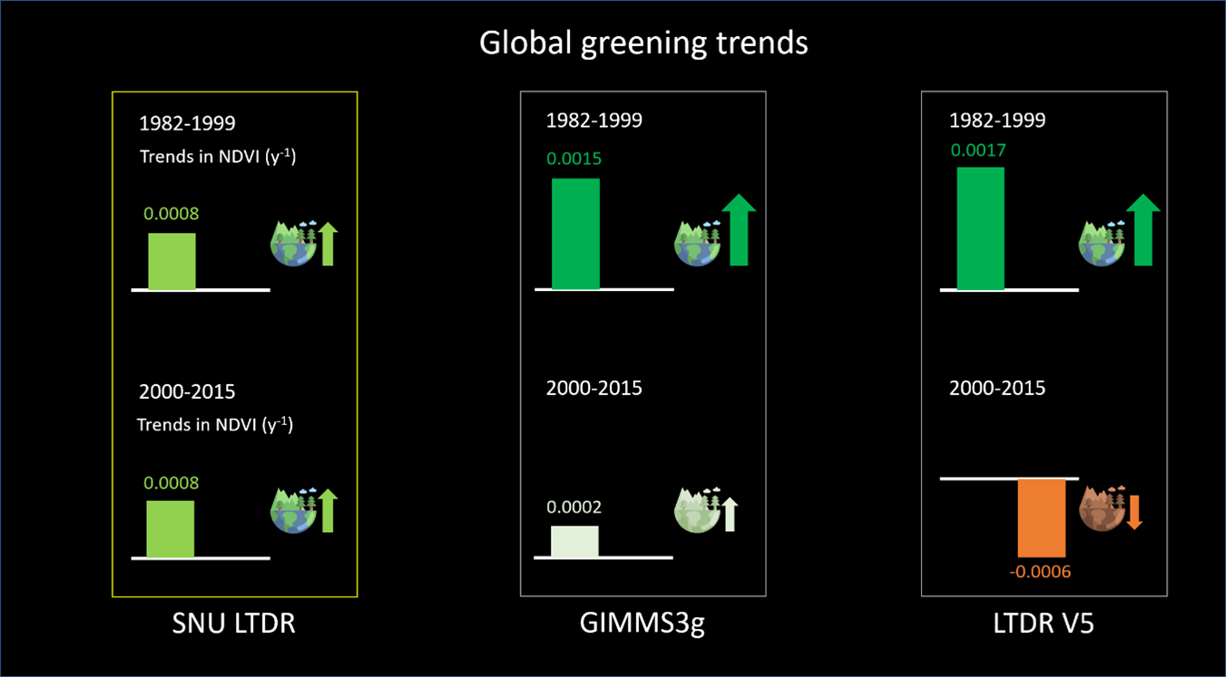
Figure 1: A comparison of the global greening trends extracted from the Seoul National University model (SNU LTDR), GIMMS3g and LTDR V5.
Conclusions
Improving temporal consistencies within datasets, therefore, are crucial to improving accuracy of vegetation index datasets allowing us to more accurately predict global vegetation trends, particularly in the context of climate change. Remaining artefacts in long-term satellite remote sensing datasets have hindered a robust evaluation of land surface models. Moving forward, this new dataset can help us better understand global vegetation dynamics
To read the full version of this paper see the citation and link below:
Jeong, S., Ryu, Y., Gentine, P., Lian, X., Fang, J., Li, X., Dechant, B., Kong, J., Choi, W., Jiang, C., Keenan, T.I., Harrison, S.P., Prentice, I.C. 2024 Persistent global greening over the last four decades using novel long-term vegetation index data with enhanced temporal consistency. Remote Sensing of Environment 311, 114282, https://doi.org/10.1016/j.rse.2024.114282