SPECIAL Group leader Sandy Harrison as involved with the publication of a new piece of work that outlines a framework to predict burnt area of wildfires using remote sensing data. The framework, now known as Fire-Image-DenseNet (FIDN) is a deep-learning model that uses both remote sensing data and climate observations to drive the predicted product.
___________________________________________________________________________________________________________________________________________
Fire-Image-DenseNet (FIDN) for predicting wildfire burnt area using remote sensing data.
___________________________________________________________________________________________________________________________________________
The trouble with modelling fire spread
Modelling fire spread and the potential final fire coverage is essential to fire response and management. This is because knowing where a fire may spread to, and how fast it may travel, enables first responders to plan evacuations, asset protection strategies and fire spread reduction techniques appropriately. However, modelling fire spread is challenging due to the heterogenous nature of landscapes and the fine scale at which the landscape can influence fire spread. Small changes in weather or even plant chemistry have the potential to influence the properties of a fire within a small, focused area.
Several models have been developed to predict fire spread including both statistical and physical modelling approaches. These include the cellular automata (CA) approach, which simulates the probability of the nearest grid cell burning. Alternatively, the Minimum Travel Time (MTT) algorithm calculates the time for a fire to move between two nodes. Both approaches are effective but require significant computational power to simulate the model environment. These models perform well across short time frames, however, degrade in performance over simulated time. Models based on the CA model with improved speed have been developed in the last couple of years, however, a model that can predict the final burned area at a fine scale is still lacking.
A new burnt area prediction
In Pang et al. 2024 the authors present a new novel deep learning method, which they have named Fire-Image-DenseNet or FIDN, to predict burnt area using a fire spread model with additional dataset inputs. These additional data include vegetation data, information on water body location, wind, topography and precipitation.
Steps to the new Fire-Image-DenseNet:
- DenseNet as a basis: DenseNet forms the foundation of the new model, DenseNet is a Connected Convolutional Network (CNN, a type of neural network used to process images) that is more efficient than other CNNs and has improved accuracy over simulated time.
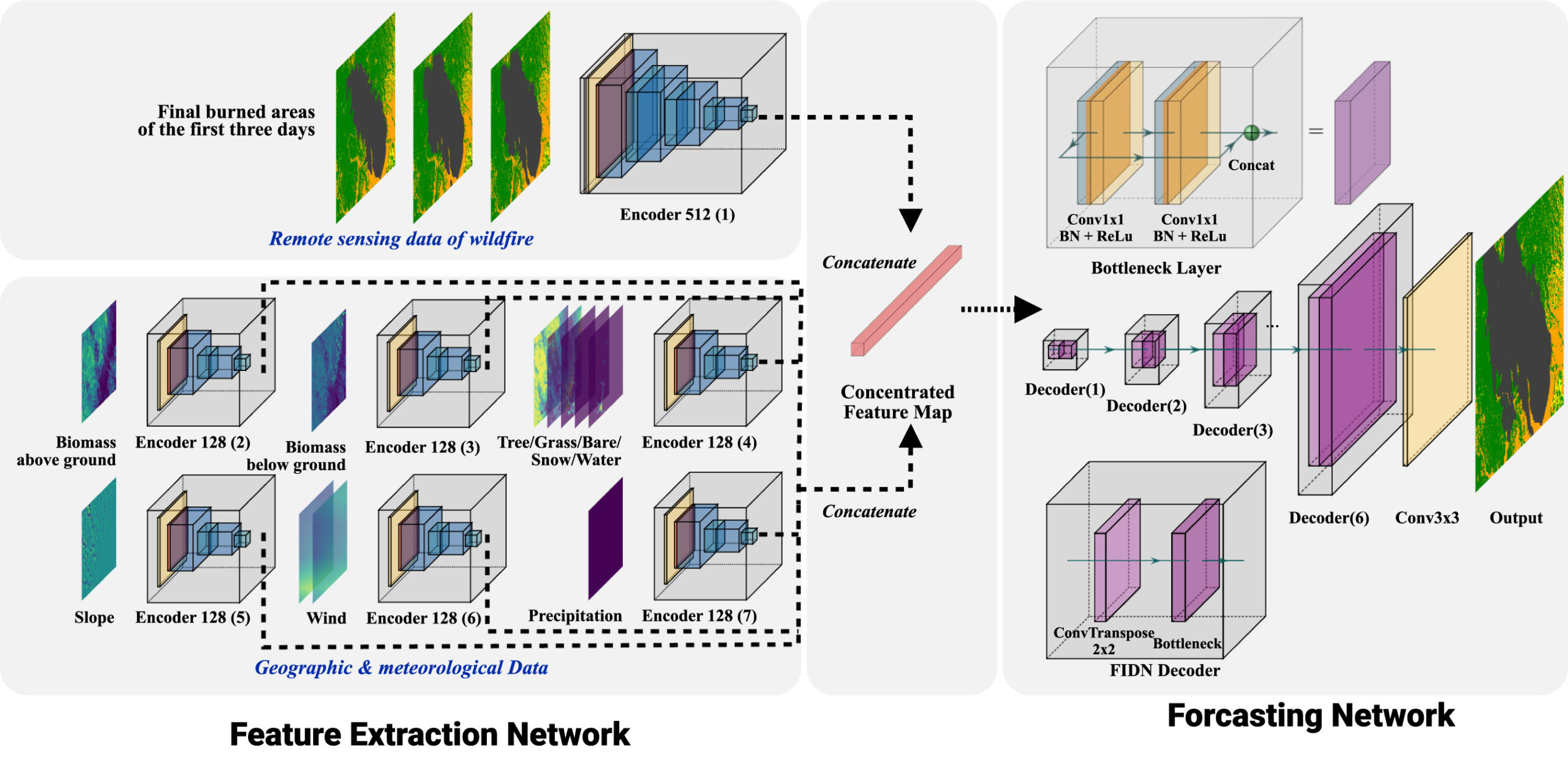
- Satellite Data and Interpolation: Burnt area data is sourced from MODIS and VIIRS satellites and DenseNet is applied.
- Environmental Data Integration: Layers like vegetation density, slope, wind speed, and precipitation are preprocessed to a 128×128 grid for uniformity using DenseNet.
- Augmented Training Dataset: A total of 243 wildfire events from 2012–2017 were augmented by rotating the data, expanding the training set to 972 samples.
- Performance of the new FIDN model is then tested with 30 validation wildfires and 30 independent wildfires from 2018-2019.

Figure 1: The FIDN Model Structure including the both the feature extraction, extractions of burned area data from remote sensing products and the formation of the predicted layer. Figure taken from Pang et al. (2025).
Fire-Image-DenseNet Performance
All models (FIDN, CA, and MTT) were tested under identical conditions on the same computer system, ensuring consistency. Inputs included the same environmental data (e.g., tree cover, slope, and density), wind components, and wildfire duration. However, CA and MTT models required exact wildfire durations, which is often impractical in real-world scenarios. When comparing the FIDN model outputs to that of CA or MTT, the improvements are significant.
Reduction in computation time – 99.92%
Improving structural similarity – 1.8%
Improving peak signal to noise ratio – 6%
Reducing mean square error – 67.7%
You can read the full paper for further information on how the FIDN model stood up against both the comparison models and to see the results from some in-depth case studies.
Conclusion and Future Usage
The Fire-Image-DenseNet (FIDN) model is a breakthrough in wildfire prediction, leveraging deep learning to forecast the final burnt area using initial burn data (first three days), along with geophysical and climate variables. Built on the efficient DenseNet architecture, FIDN produces accurate predictions regardless of fire size or duration while significantly reducing computational costs and time. By incorporating remotely sensed data from sources like MODIS, FIDN of fers the potential for dynamic updates, adapting to changes in fire behaviour. Future research aims to integrate real-time data for forecasting, enabling strategic planning such as placing fire retardants or creating fire breaks. This adaptable, data-agnostic model could be applied globally, empowering land managers and fire services to respond more effectively, minimizing the environmental and societal impacts of wildfires.
Read the full paper here: Bo Pang, Sibo Cheng, Yuhan Huang, Yufang Jin, Yike Guo, I. Colin Prentice, Sandy P. Harrison, Rossella Arcucci. 2025. Fire-Image-DenseNet (FIDN) for predicting wildfire burnt area using remote sensing data, Computers & Geosciences,195,105783, https://doi.org/10.1016/j.cageo.2024.105783.
The SPEICAL group will be taking a short break over the holiday period but we have a number of other exciting papers at various stages of publication so stay tuned for the latest updates from the group!
