A quick guide to using TAMSAT rainfall and soil moisture estimates can be found here.
What is TAMSAT?
TAMSAT* enhances the capacity of African meteorological agencies and other organisations by providing and supporting the use of satellite-based rainfall estimates, soil moisture estimates and forecasts, and related data products.
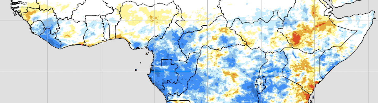
TAMSAT produces daily rainfall estimates for all of Africa at 0.0375° x 0.0375° degrees, as well as soil moisture estimates and forecasts (out to 160 days) for all of Africa at 0.25° x 0.25°degrees. The TAMSAT rainfall and soil moisture archives span 1983 to the delayed present. The longevity of these datasets makes them especially suitable for risk assessment. Applications of the data include famine early warning, drought insurance and agricultural decision support.
TAMSAT rainfall and soil moisture estimates are issued on the 1st, 6th, 11th, 16th, 21st, and 26th of the month. All TAMSAT data are released for operational, research and commercial use under a creative commons license.
TAMSAT was established by the University of Reading in 1977 and has been gathering data continuously since 1983. In the last three years, the group has developed close collaborations with the Climate Division of the National Centre for Atmospheric Science (NCAS) and the National Centre for Earth Observation (NCEO), collaborating with several international partners, to extend the range of climate services it provides. These collaborations are supporting the development of new datasets and other products, including rainfall estimate uncertainties, full column soil moisture, and probabilistic forecasts of drought. This supports the University of Reading’s commitment to the United Nations Sustainable Development Goals (SDGs).
TAMSAT Soil Moisture Data – Operational Update
Update (31/03/2026):
TAMSAT soil moisture v2.3.1 has now resumed operational production using ERA5-Land as the forcing dataset. Soil moisture data from 18/03/2026 onwards are therefore derived from ERA5-Land forcing. Initial assessments indicate that the new data are broadly consistent with the previous NCEP-forced product, although small inhomogeneities cannot be ruled out due to the change in forcing dataset. A new ERA5-Land-forced historical TAMSAT soil moisture record covering 1983 to present will be released in the coming months to provide a consistent long-term dataset. Please contact us if you have any queries about this transition (tamsat@reading.ac.uk).
*TAMSAT stands for Tropical Applications of Meteorology using SATellite data and ground-based observations.
🇫🇷 Pour soutenir l'objectif de TAMSAT d'améliorer la capacité en Afrique à utiliser les données dérivées des satellites pour les services climatiques, nous avons mis à disposition certains de nos principaux documents en français.
