TAMSAT-ALERT – forecasting of agricultural drought
Summary
Early warning of drought is crucial for a range of decision makers to mitigate their exposure to risk. For small-scale farmers, reliable information on the likelihood of drought can inform decisions about when to prepare land, plant and apply topdressing, which variety of seeds to buy and plant, how best to manage grazing resources, and post-harvest decisions around selling and storage. Drought information is also important to a range of decision makers who require an understanding of drought risk to inform their activities to mitigate drought impacts (for example, in the humanitarian and financial sectors).
Multiple sources of environmental information are available to support decision making around drought risk, including remotely-sensed and ground-based measures of rainfall and soil moisture, model reanalyses and meteorological forecasts.
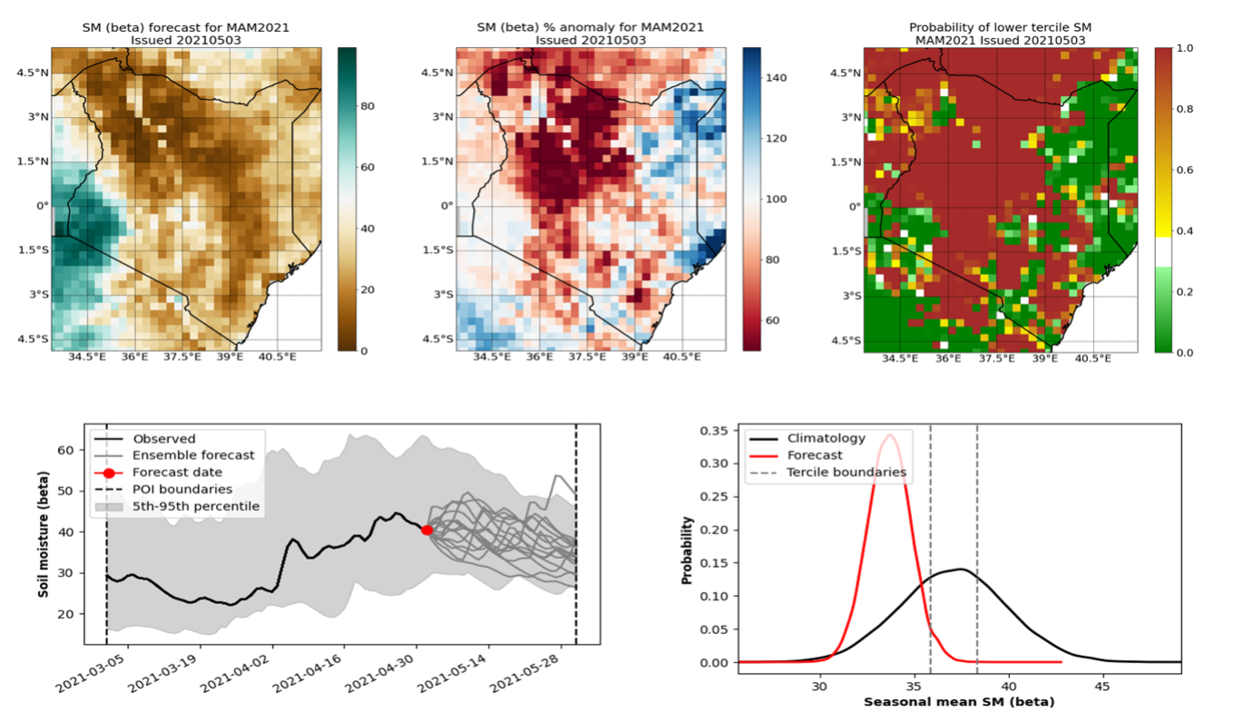
An exciting new development for TAMSAT is the capacity for forecast agricultural drought – defined as deficit in soil moisture that leads to plant water stress. These forecasts are undertaken using the TAMSAT-ALERT framework. TAMSAT-ALERT (TAMSAT–AgriculturaL Early waRning sysTem) is a monitoring and decision support tool that makes use of such data streams to assess and anticipate the risk of drought.
How does TAMSAT-ALERT work?
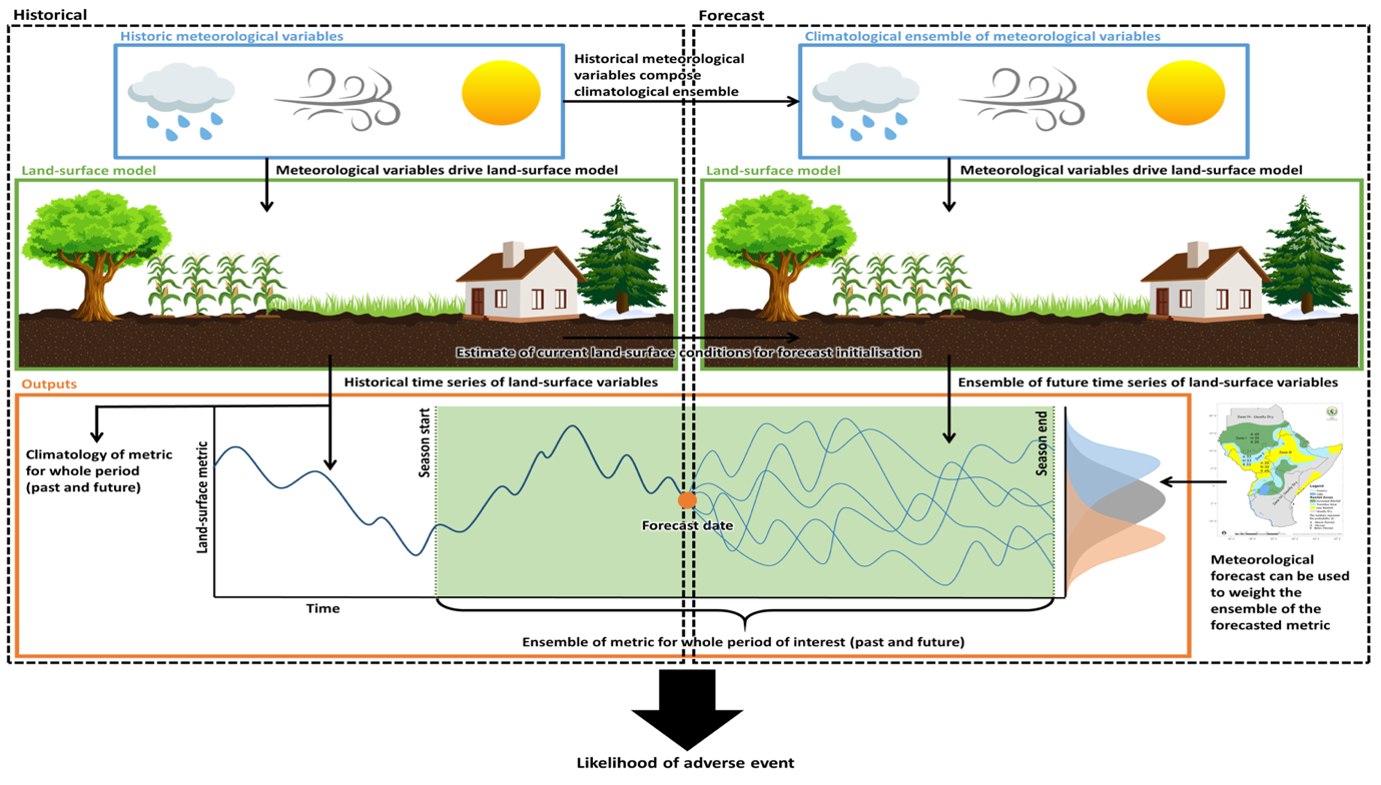
TAMSAT-ALERT provides reliable forecasts of land-surface conditions (namely, soil moisture) at timescales from weeks (for germination) to months (for crop yield). It does so by using meteorological variables to drive a land surface model.
Historical: Historical meteorological variables (including rainfall, wind and temperature) are used to drive the land-surface model to produce a historical timeseries (1983-present) of land-surface variables. The historical time series of land-surface metrics provides a climatology of land-surface metrics for the period of interest.
Forecast: Historical meteorological variables are used to construct the climatological ensemble of meteorological variables. The initial conditions of the land-surface model are estimated from the historical run. Using each of the climatological ensemble members, the land-surface model is driven forward in time to produce an ensemble time series of future land-surface conditions. Combining the historical timeseries and ensemble of future land-surface variables, an ensemble of the land-surface metric of interest can be derived for the whole period (incorporating the historic or observed period and the forecast period). The ensemble can be weighted based on a related meteorological forecast. Considering both the historical and ensemble time series, the likelihood of an adverse event (drought) can be estimated.

In doing so, TAMSAT-ALERT considers the…
- historical weather conditions (climatology)
- current state of the land surface
- evolution of the growing season
- meteorological forecast (e.g. tercile rainfall forecast)
to assess the risk of an adverse event (e.g. drought) occurring. The land surface model also accounts for variation in soil and vegetation type, including the growth parameters of a chosen crop.
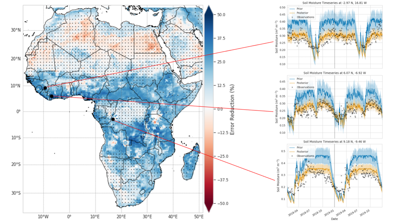
The latest version of TAMSAT-ALERT uses the LAVENDAR hybrid data assimilation technique to combine observations from the NASA Soil Moisture Active Passive (SMAP) satellite mission with the Joint UK Land Environment Simulator (JULES) land surface model to optimise soil parameters and water budget variables. The technique combines prior model estimates with observations over the whole spatial domain and a year’s time window in an instantaneous assimilation step, retrieving parameters that are valid in space and time.
Applications
A number of applications of TAMSAT-ALERT are currently being piloted across Africa.
Across eastern and southern Africa, the Red Cross are examining the ability or TAMSAT-ALERT soil moisture forecasts to reliably anticipate drought at lead times which allow for early (preparatory) action. Initial results are promising and, if successful, TAMSAT-ALERT will support the Red Cross’ movement towards Forecast-based Action: acting before a disaster hits to mitigate the worst impacts, potentially saving lives and livelihoods and sparing limited resources.
In Kenya, the National Drought Management Authority (NDMA) have been piloting TAMSAT-ALERT soil moisture forecasts in their monthly drought bulletins. The NDMA’s bulletins are widely using by county-level government and other organisations to plan for possible drought conditions. TAMSAT-ALERT was initially piloted in Kitui county in 2019’s short rainy season (October-December). Forecasts indicated a low probability of drought, which meant 300,000 farmers were moved from the “Alert” phase of food security to the “Normal” phase, allowing limited resources to be diverted from short-term drought preparedness activities to long-term resilience building investments. Subsequently, TAMSAT-ALERT was successfully piloted in seven of Kenya’s most vulnerable counties. The NDMA plan to scale-up the use of TAMSAT-ALERT forecasts to all counties by the end of 2021.
Shorter-term (2-3 weeks) TAMSAT-ALERT soil moisture forecasts are also being used to provide planting date decision support to smallholder farmers through the One Acre Fund. This was first piloted in early 2020, in which TAMSAT-ALERT provided live planting date advice via SMS to agricultural extension workers representing approximately 70,000 farmers. Advice allowed farmers to plant early and benefit from an unusually long growing season.
TAMSAT-ALERT seasonal forecasts have also informed World Food Programme (WFP) bulletins in Zambia. The suitability of TAMSAT-ALERT based climate services are currently being explored with the Nigerian, Kenyan and Ghanaian NHMS, and the Red Cross are currently fine-tuning triggers based on TAMSAT-ALERT forecasts for use in Early Action Protocols in Kenya, Uganda, Ethiopia, Lesotho, Mozambique and Namibia. Many applications of TAMSAT-ALERT will be piloted throughout 2020 and operationalised thereafter.
How to use TAMSAT-ALERT?
- TAMSAT-ALERT API: https://github.com/TAMSAT/TAMSAT-ALERT_API
You can generate real-time TAMSAT-ALERT soil moisture forecasts for yourself using our Python-based TAMSAT-ALERT API. The API allows you to identify a region and season of interest and then extracts the relevant soil moisture forecast. You can access the API and guidance documents on the TAMSAT GitHub. The API is publicly available and free to use.

- Historical TAMSAT-ALERT data: http://www.tamsat.org.uk/data
The historic TAMSAT-ALERT soil moisture data can be obtained via the Data page of our website.
- If you have further TAMSAT-ALERT data needs, please get in touch (tamsat@reading.ac.uk).

