After a 1-year delay due to the Covid-19 pandemic, the Arctic summer-time cyclones field campaign took place in July and August 2022, where we flew through Arctic cyclones and took the measurements required to investigate the two-way cyclone-sea ice interaction. The primary aim of the field campaign was to (i) map cyclone structure and (ii) obtain measurements of near-surface fluxes of momentum, heat and moisture over sea ice and ocean (as these fluxes dictate the impact of the surface on the atmosphere). To obtain accurate measurements of near-surface fluxes, we need to be quite close to the surface (no higher than 300 ft). To do this, we would be using BAS’s Twin Otter aircraft, equipped with Meteorological Airborne Science INstrumentation (MASIN). The twin-engine prop aircraft is ideal for flying at low-levels just above the surface (as low as 50 ft!). There are many instruments fitted on the MASIN research aircraft, but the most important measurements for our purposes were temperature, wind speed and direction, humidity (important for mapping cyclone structure), surface layer turbulent fluxes (from the 50 Hz turbulence probe), and ice surface properties (from laser altimeter).
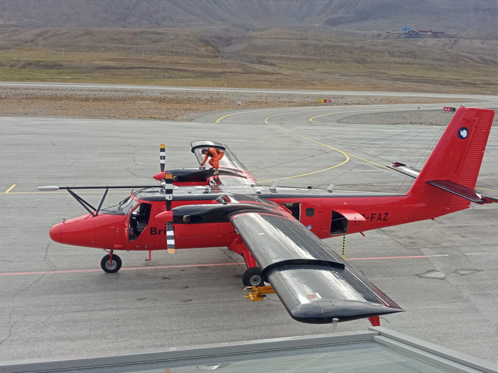
British Antarctic Survey’s Twin Otter aircraft, fitted with the MASIN equipment. You can see the turbulence probe on the boom at the front of the aircraft, and the CAPS (cloud, aerosol, and precipitation spectrometer) probe on the left wing. The pilot is on top of the aircraft, carrying out final checks before a science flight. Photo from John Methven.
The field campaign team, comprised of scientists, engineers and pilots from the University of Reading, the University of East Anglia, and British Antarctic Survey (BAS), were based on the Norwegian archipelago of Svalbard, a 3-hour flight north of Oslo. The team was based in Longyearbyen, the main town on Svalbard. At 78°N, Svalbard is the most northern town in the world! Longyearbyen is located within a valley on the shore of Adventfjorden. The town is a strange but charming place with lots of eccentricities. Longyearbyen is populated with wooden buildings, with pipes above the ground (as the ground freezes in winter), and old mining structures on the sides of the valley. The town is small, but well provided for, with a few tourist shops, restaurants, and a supermarket. As Svalbard is in the Arctic circle, during the summer months it experiences 24-hour sunlight, which was very strange! Furthermore, Longyearbyen is one of the only places on Svalbard that is ‘polar bear safe’ – you should only leave the town limits if you have a rifle!
The field campaign team worked at Longyearbyen airport. The team would study the forecasts from different weather models for the next week, to decide on flight plans. We were primarily looking for strong winds (ideally associated with cyclones, but beggars can’t be choosers!) over the sea ice, within range of the Twin Otter aircraft (approximately 600 nautical miles). With flight planning, there were many things to consider. It was a case of waiting for good weather to come to us, and planning rest days for the pilots when the weather wasn’t looking so interesting in the forecast. Flight plans would consist of transit to and from the target region, where science would be conducted. Science flying included low-level legs to obtain turbulent flux measurements, vertical profiles of the boundary layer, and stacked cross-sections through cyclone features (e.g. fronts) in and above the boundary layer. For flights where low-level flying was planned, it was key that there should not be low cloud in the target area, as this would prevent the aircraft from flying below 1000 ft for safety reasons. It was also important that there were not bad conditions (poor visibility or strong winds) in Longyearbyen, which would prevent the aircraft from taking off or landing. Longyearbyen is an isolated airfield, and the aircraft cannot carry enough fuel to make it back to the mainland if conditions are too poor to land, so this was a very important consideration. Furthermore, the American and French THINICE project field campaign was being conducted at the same time in Svalbard, with the SAFIRE ATR42 aircraft flying at higher levels, looking downwards on Arctic cyclones. We were able to co-ordinate several flights through the same weather systems, with the Twin Otter aircraft flying below the ATR42.
The Twin Otter aircraft holds 3-4 people, including the pilot. With an instrument engineer also on board, this left space for 1 or 2 scientists on each flight (Note: to fly on the aircraft we had to do helicopter underwater escape training – see my previous blog at https://socialmetwork.blog/2021/07/16/helicopter-underwater-escape-training-for-arctic-field-campaign/). The cabin is very small (too small for a person to stand up), and is rather cramped, with a considerable amount of space taken up by the extra range fuel tank! The aircraft is flown between 50 and 10,000 ft, and so the cabin is not pressurized. For low-level flying, the crew must wear immersion suits and life jackets on the aircraft (in the unlikely event that the aircraft must ditch in the ocean). On the flight the crew wear noise-cancelling headphones (as the engines are rather loud), and everyone can speak to each other over the intercom. During the flight the scientists will alter the flight plan if necessary, depending on the conditions they encounter, and take notes of the environment and any notable events that occur during the flight. This includes noting what they can see out of the window (e.g. sea ice fraction, cloud), any interesting observations from the live feed of the instrument output within the aircraft (e.g. boundary layer depth), and any instruments that are not working or faulty.
I had the opportunity to fly on the aircraft on the third science flight of the field campaign (I wrote about this in another blog: https://research.reading.ac.uk/arctic-summertime-cyclones/first-field-campaign-flying-experience/). We were targeting a region to the north-west of Svalbard, in the Fram Strait, where there was forecast to be strong northerly winds over the marginal ice zone. The primary objective was to measure turbulent fluxes over sea ice at low-level. However, on reaching the target region, we were unable to descend lower than 500 ft due to cloud and Arctic sea smoke (formed as cold Arctic air moves over warmer water in between the sea ice floes) at the surface – not safe conditions for flying at low-level! Through gaps in the clouds, we got a glimpse at the Arctic sea smoke over the marginal ice zone (see below). (Note: Several other flights in the field campaign encountered better conditions and were able to get to low levels – see video below!). We searched for better conditions near the target region for an hour, but didn’t find any, so made the return trip home. It was a shame that we could not fly low enough to obtain turbulent flux measurements, but the flight was still useful for obtaining profiles of wind structure in the boundary layer, and for our understanding of forecast performance in the region.
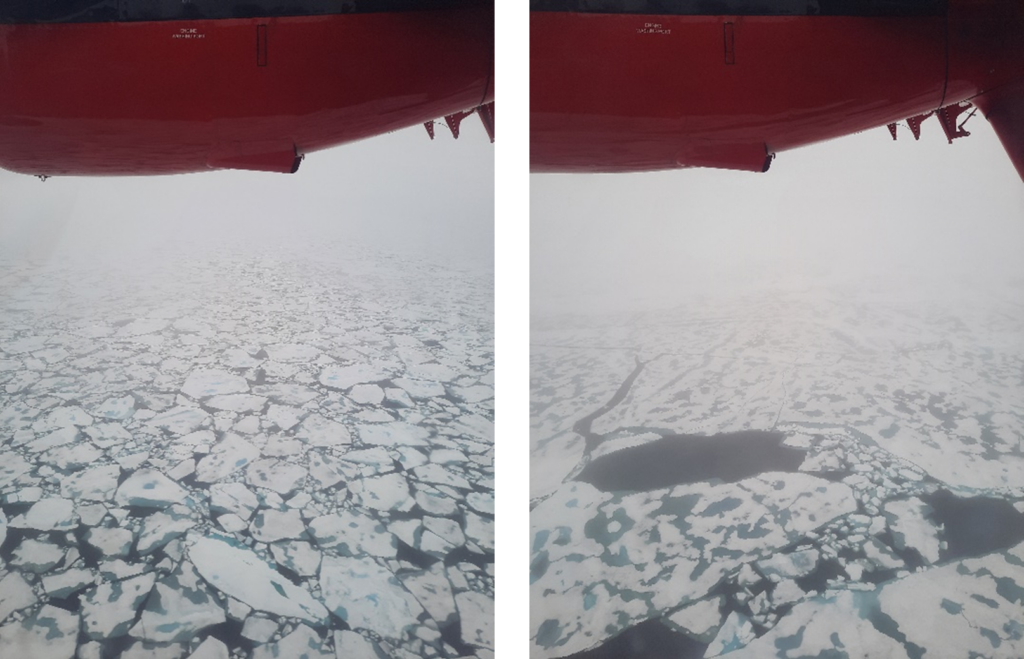
Photos taken from the Twin Otter aircraft 500 ft above the surface, with a layer of Arctic sea smoke overlaying the ice floes of the marginal ice zone. Here visibility is too low to descend any further. Photos from Hannah Croad.
Just back from two days of awesome low level flights measuring atmospheric fluxes and ice roughness over the marginal ice zone from Station Nord, only 933km from the North Pole pic.twitter.com/Zc9VR3mD0l
— John Methven (@JohnMethven7) August 20, 2022
Flying over the marginal ice zone at 70 ft in good visibility conditions, with the shadow of the Twin Otter aircraft visible. Video from John Methven.
During the month-long field campaign a total of 17 science flights were conducted, flying in all directions from Longyearbyen, with an accumulated 80 hours of flying time. This included 4 Arctic cyclone cases, and 7.5 hours of surface layer turbulent flux measurements (more than we could have hoped for!). The data from the aircraft is currently undergoing quality control. Analysis will now proceed in two streams:
- Run simulations of Arctic cyclone cases in NWP models, evaluating against field campaign observations and using various tools to relate surface friction and heating to cyclone evolution (led by the University of Reading team)
- Use observations of turbulent fluxes in the surface layer over the marginal ice zone and sea ice properties to improve the representation of turbulent exchange over sea ice – i.e. develop parametrizations (led by the University of East Anglia team)
Building on the outputs and findings from these two work packages, we will then run sensitivity experiments of Arctic cyclones in NWP models, using the revised turbulent exchange parametrizations, to understand the impact on cyclone development.
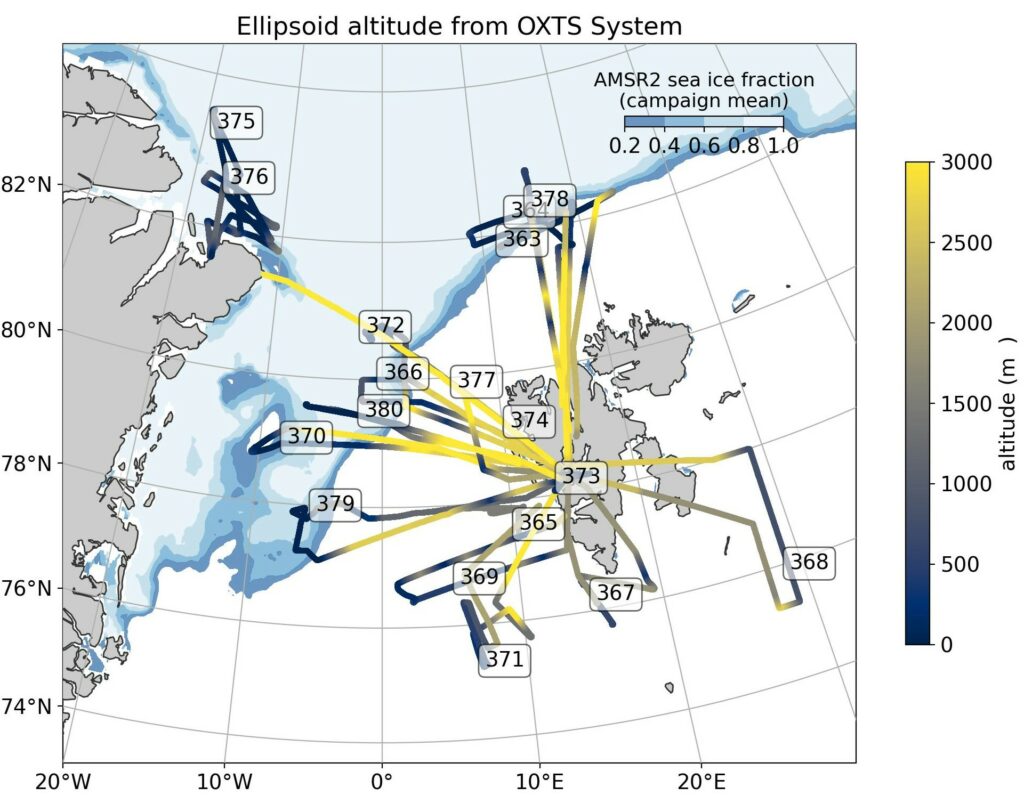
A summary of all the science flights conducted during the Arctic Summer-time Cyclones field campaign. Flight routes are coloured blue-yellow, indicating flight altitude. Also plotted is the campaign mean sea ice fraction (AMSR2).
I really enjoyed my time on the field campaign, and I learnt a lot! It was great to help the team with forecasting and flight planning, and to be on a science flight. I also got to do a bit of media work, talking on BBC Radio 4’s Inside Science programme (https://www.bbc.co.uk/programmes/m0019z2y). It was a fantastic experience, and now the team and I are looking forward to getting started with the analysis and using the data!
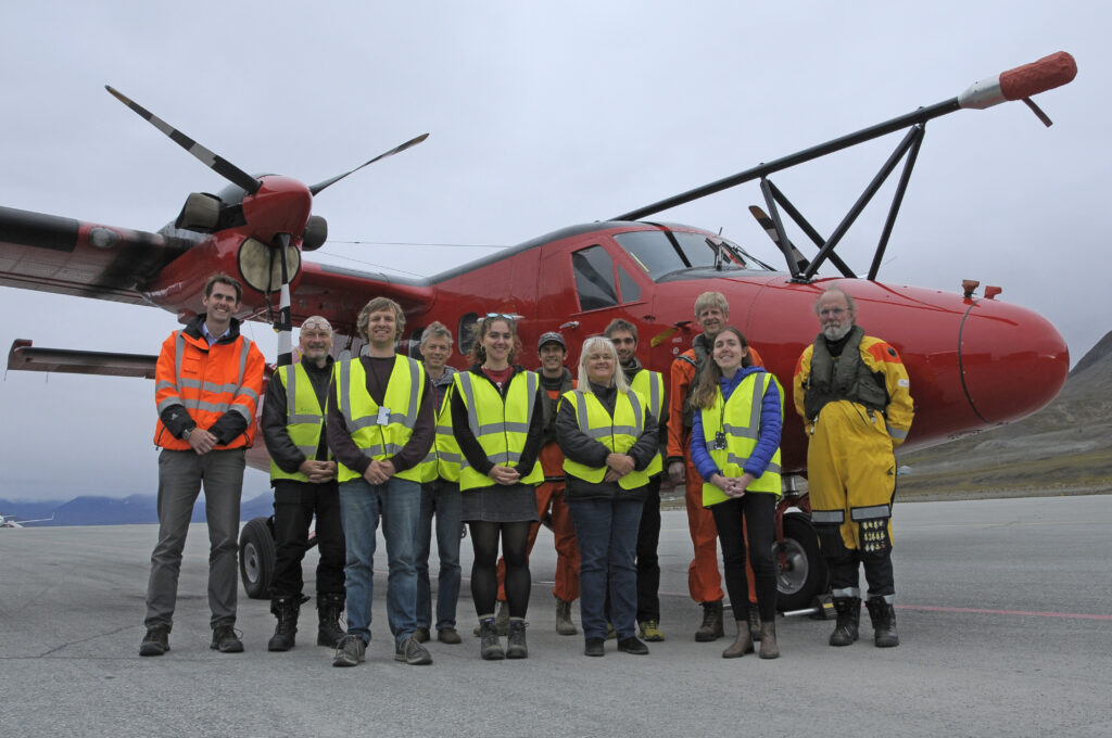
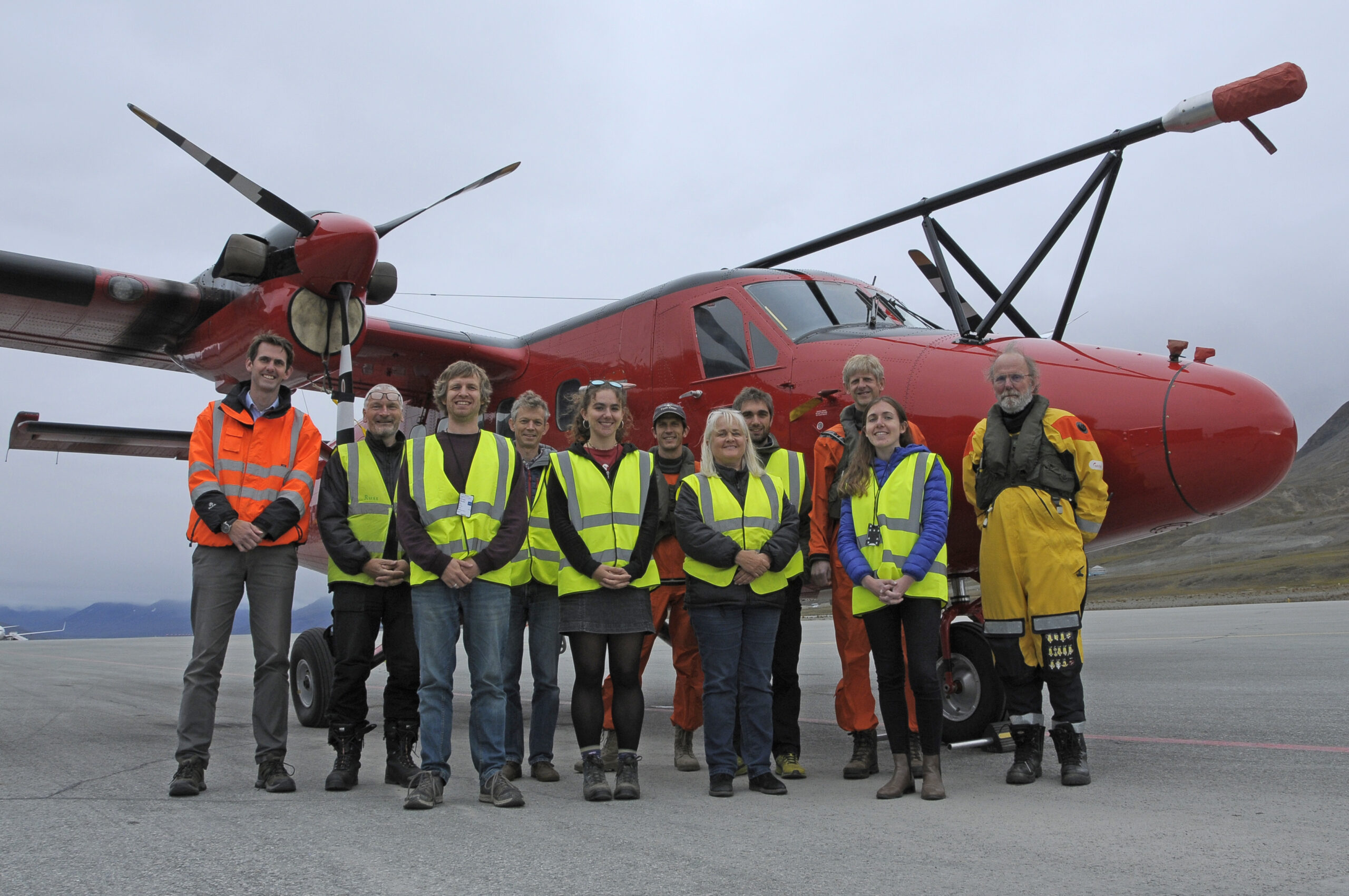
Arctic Summer-time Cyclones field campaign team (some missing) in front of the Twin Otter aircraft. Photo from Dan Beeden.