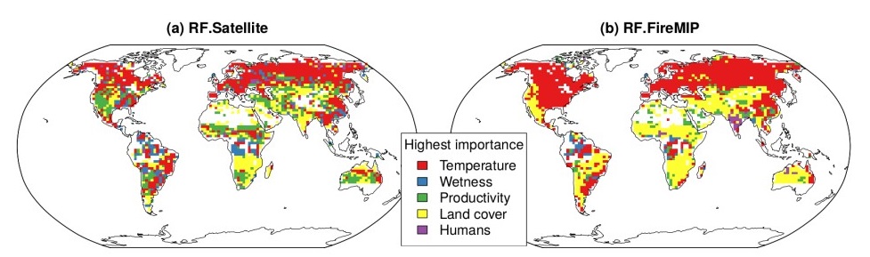
Our new paper on the emergent relationships between key climate, vegetation and socioeconomic variables and burned area as seen in satellite observations and as captured by fire-enabled vegetation models has appeared in Biogeoscience Discussions this week (https://www.biogeosciences-discuss.net/bg-2018-427/). The satellite-derived relationships indicate strong sensitivity to climate variables (e.g. maximum temperature, number of wet days), vegetation properties (e.g. vegetation type, previous-year plant productivity and leaf area, amount of woody litter), and to socioeconomic variables (e.g. human population density). DGVMs broadly reproduce the relationships to climate variables, but underestimate the strength of the relationships to vegetation properties and their impact on year-to-year changes in the amount of fire. Improvements in the modelling of fuel production and fuel loads are necessary in order to be able to predict the evolution of fire regimes in the future. Models showed very different relationships with socioeconomic variables, reflecting differences in how human influences on fire regimes are implemented in each model. There is a fundamental lack of understanding about how humans shape fire regimes – many models implement emergent relationships with socioeconomic factors which in fact reflect climate and environmnetal drivers of both human activities and fire. The study in Biogeosciences Discussions is an important outcome of the FireMIP model intercomparison project, designed to provide a more secure basis for fire model development.