by Riccardo Monfardini, March 2025
In this blog post, I will briefly introduce how land surface temperature (LST) is measured from satellites, the associated challenges, and the results. My name is Riccardo Monfardini and I am a second-year PhD student at Reading University working on the assimilation of LST in numerical weather models. I have spent the first part of my project understanding the data currently available compared with model data, with particular emphasis on LST data provided by The Satellite Application Facility on Land Surface Analysis.
Land surface temperature
LST can be retrieved from satellites observing the Earth. We say “retrieved” because satellites only infer the radiometric temperature based on the relationship between the radiation emitted by the surface and its temperature. One of the main retrieval methods is the generalized split-window algorithm [1,2] which uses the observations from the IR channels usually centred near 11 and 12 micrometres wavelengths. Considering the average and difference in radiometric emission between the two channels (converted to the brightness temperature of a black body), a parametric relationship can be created with the underlying LST as shown here
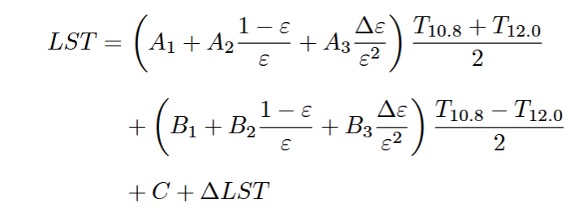
T10.8 and T12.0 are the brightness temperatures of the respective IR channels, ε is the average of the two channels’ surface emissivities; Δε is their difference (ε10.8 − ε12.0), ΔLST is the model error, and As, Bs and C are coefficients.
Uncertainties
The A, B and C coefficients are determined via calibration against a reference dataset of atmospheric profiles. They depend on two factors:
- the total water vapour content (TWVC) in the atmosphere along the viewing path, which partially obscures the surface signal by absorbing and emitting radiation.
- the satellite viewing angle, which affects the apparent land surface geometry and modifies the emitted radiation.
Calibration is performed by assigning profiles to different classes of viewing angle and TWVC, but of course, they introduce uncertainty, and at a very large angle the relationship becomes very non-linear making the use of these data difficult.
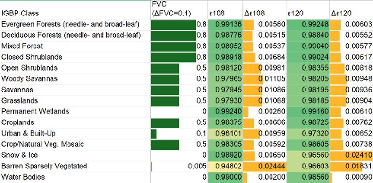
Another challenge is assigning the correct emissivity to the underlying surface. This is a non-trivial problem as it depends on specific emissivity for each channel and the type of surface. In general, the surface emissivity is estimated as a weighted average between the fraction of vegetated cover (FVC) and the bare ground emissivity. The table below presents typical values for various land covers and their associated uncertainty [3].
Clouds
Finally, this retrieval method only works in clear skies, as IR channels cannot penetrate the clouds. This means that a cloud mask is applied to the data before processing, but no cloud mask is perfect. Any cloud infiltration will bring errors in the retrieval, typically appearing as artificially colder LST values due to the lower cloud top temperature. Similarly, dust and aerosols can impact retrieval accuracy by scattering and absorbing IR radiation.
Result
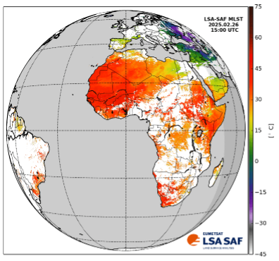
Aside from these issues, LST is retrieved from satellites across the globe. Below is an example taken from the LST retrieval using a geostationary satellite, the Meteosat Second Generation with the Spinning Enhanced Visible Infra-Red Imager instrument [4]. Clear skies pixels show the LST according to the colour bar, the sea pixels are masked in grey, and land pixels with clouds are left blank.
My PhD research focuses on assimilating this data into numerical weather models, carefully accounting for uncertainties and biases, particularly those varying across the diurnal cycle. While sea surface temperature is routinely assimilated into many numerical weather models, LST assimilation remains challenging due to land surface heterogeneity, higher emissivity uncertainty, and other complicating factors.
References
- Wan, Z. & Dozier, J. A generalized split-window algorithm for retrieving land-surface temperature from space. IEEE Transactions on Geoscience and Remote Sensing 34, 892–905 (1996).
- Trigo, I. F., C. C. DaCamara, P. Viterbo, J.-L. Roujean, F. Olesen, C. Barroso, F. Camacho-de Coca, D. Carrer, S. C. Freitas, J. García-Haro, B. Geiger, F. Gellens-Meulenberghs, N. Ghilain, J. Meliá, L. Pessanha, N. Siljamo, and A. Arboleda, 2011: The Satellite Application Facility on Land Surface Analysis. Int. J. Remote Sens., 32, 2725-2744, doi: 10.1080/01431161003743199
- Freitas, S. C., Trigo, I. F., Bioucas-Dias, J. M. & Gottsche, F.-M. Quantifying the Uncertainty of Land Surface Temperature Retrievals From SEVIRI/Meteosat. IEEE Transactions on Geoscience and Remote Sensing 48, 523–534 (2010).
- LSA SAF data found at https://nextcloud.lsasvcs.ipma.pt/s/FY7PCYqFfXMrMZy


