
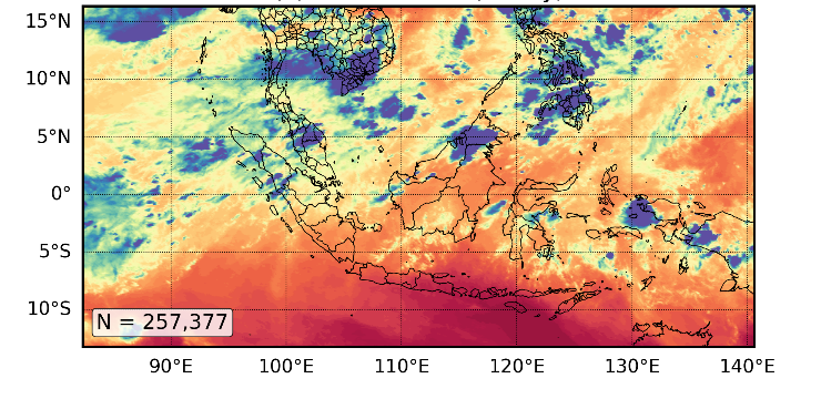
by Miranti Indri Hastuti, May 2026
The importance of clouds
Clouds are central to the atmosphere. They regulate the Earth’s energy balance, transport heat and moisture, and drive high-impact weather such as heavy rainfall, thunderstorms, and tropical cyclones. In many regions, particularly the tropics, forecast errors are closely linked to how clouds are represented.
Predicting clouds remains difficult. They evolve rapidly, vary across a wide range of scales, and often occur below the resolution of numerical weather prediction (NWP). Radar provides detailed insight into cloud structure, especially for convection and precipitation, but its coverage is uneven globally and thin clouds may be missed. Satellites therefore provide a crucial complementary perspective, offering continuous, global observations, particularly over data-sparse ocean regions.
How do satellites observe the Earth?
Satellites do not measure atmospheric variables directly. Instead, they observe radiation emitted or reflected by the Earth–atmosphere system, expressed as brightness temperature. These measurements vary with atmospheric conditions and provide indirect information about temperature, water vapour, and clouds.
Different wavelengths are sensitive to different atmospheric layers. This relationship is described by a radiative transfer model (RTM), or observation operator, which links satellite observations to the model state in data assimilation systems.
Microwave, visible, and infrared observations
Satellite observations are commonly grouped into microwave, infrared (IR), and visible sensors, each providing complementary information.
Microwave sensors, typically on polar-orbiting satellites, can partially penetrate clouds and are sensitive to temperature, humidity, and precipitation. This allows them to probe deeper into the atmosphere, making them highly valuable for NWP. In the European Centre for Medium-Range Weather Forecasts system, they contribute more than 30% to short-range forecast error reduction (Geer et al., 2017).
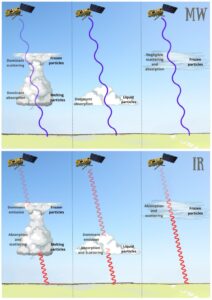
Infrared sensors, often from geostationary satellites such as Himawari-9, provide higher spatial resolution and much more frequent observations, typically every 10–15 minutes. This is especially important in tropical regions, where microwave overpasses may be separated by several hours. However, infrared radiation is strongly affected by clouds: thick clouds block radiation from lower layers, so observations mainly represent cloud-top properties and the atmosphere above. Figure 1 highlights the greater cloud penetration of microwave signals and the stronger attenuation of infrared radiation.
Visible sensors provide an additional perspective by measuring reflected sunlight. They offer very high-resolution information on cloud structure and optical properties, supporting cloud identification and tracking. However, they are limited to daytime and provide little information beneath cloud layers.
Together, these observing systems are complementary: microwave observations probe atmospheric structure within and beneath clouds, infrared observations capture cloud evolution at high temporal frequency, and visible observations provide detailed cloud morphology.
Challenges and progress in satellite data assimilation
Satellite observations provide a vast source of information, but using them effectively in data assimilation remains challenging. At the core is the observation operator (RTM), which links atmospheric variables to radiances and is often highly non-linear, particularly in cloudy conditions.
The complexity varies across the spectrum. Microwave radiances are relatively smooth and easier to assimilate. In contrast, infrared radiances are strongly affected by clouds (especially ice clouds) and require detailed representation of cloud microphysics. Small errors in cloud properties or cloud-top height can lead to large discrepancies in simulated radiances.
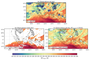
As a result, many systems have traditionally relied on clear-sky assimilation, particularly for infrared observations, excluding cloud-affected data. While simpler, this approach discards a large fraction of available data. Figure 2 highlights this contrast, showing that all-sky infrared approaches after quality control to remove poorly simulated thick ice-cloud radiances (2c) retain substantially more observations than clear-sky methods (2b).
Recent progress has focused on all-sky assimilation, which uses observations in both clear and cloudy conditions. Advances in RTM and state-dependent observation error models have made this increasingly feasible.
Visible observations introduce additional challenges due to their dependence on solar illumination, surface reflectance, and viewing geometry, limiting their use to daytime conditions. Their assimilation remains an active area of research.
Broader impact
Improving the use of satellite observations directly benefits weather prediction. Better representation of clouds leads to more accurate initial conditions, crucial for forecasting high-impact events. Beyond weather forecasting, advances in satellite data assimilation also support climate monitoring and disaster risk reduction, making them essential for future Earth system prediction.
References
Geer et al. 2017: The growing impact of satellite observations sensitive to humidity, cloud and precipitation. QJRMS. https://doi.org/10.1002/qj.3172
Viggiano et al. 2025: Combining Passive Infrared and Microwave Satellite Observations to Investigate Cloud Microphysical Properties: A Review. Remote Sensing. https://doi.org/10.3390/rs17020337