Lead Supervisor: Jonathan Mackay, British Geological Survey, Keyworth, Nottinghamshire
Email: joncka@bgs.ac.uk
Co-supervisors: Anne Verhoef, Department of Geography and Environmental science, University of Reading; Christopher Jackson, British Geological Survey, Keyworth, Nottinghamshire; Dr John Bloomfield, British Geological Survey, Wallingford, Oxfordshire
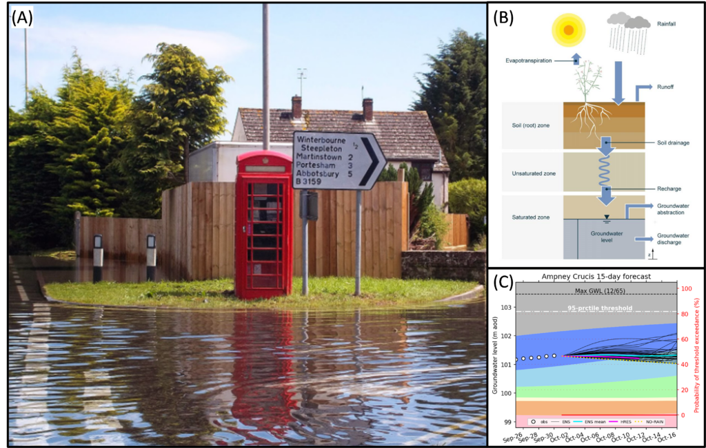
Groundwater flooding in Dorset during the summer of 2012 (A); a schematic of the AquiMod groundwater model (B); and an example 15-day ahead groundwater level forecast at a borehole situated in the Jurrasic Limestones of Gloucestershire
Groundwater provides a third of public water supply in England, and makes an important contribution in Wales and Scotland. Groundwater typically has a longer residence time than surface water sources like rivers and lakes and can, therefore, provide a more reliable source of water to communities, industry and the environment. Even so, under sustained periods of dry or wet weather, groundwater is itself, susceptible to extremes which have their own characteristic features and impact. For example, dry periods can lead to excessive lowering of the water table (groundwater drought) which can inhibit groundwater abstraction and threaten water supply. Conversely, heavy rainfall can result in the emergence of groundwater at the land surface (groundwater flooding). A characteristic feature of groundwater flooding events is the relatively long duration which can cause significant damage to property and infrastructure. The UK weather is expected to become more variable and extreme, with longer dry periods and more intense wet periods, which could increase the number of groundwater extreme events in the future[1].
Operational groundwater level forecasting systems can build community resilience to the impacts of groundwater extremes by providing early warning of extreme events[2]. These work by driving models that simulate the movement of infiltrated rainfall underground (groundwater models) with real-time weather forecasts to provide advanced warning of groundwater extremes up to months ahead of time[3]. However, our ability to accurately forecast groundwater extremes is currently limited by our lack of understanding of the hydrogeological processes that control groundwater level response to climate. These processes (e.g. water flow through the vadose zone) are difficult to observe, dependent on poorly-constrained hydrogeological properties of the subsurface, and result in non-linear and non-stationary behaviours[4] that are difficult to replicate with groundwater models.
Many models of varying complexity have been developed that translate our perceptions of groundwater processes into conceptual models (representation by equations). Our inability to discriminate between these competing conceptual models leads to uncertainty in our forecasts. By comparing their performance, we gain knowledge about the processes operating, and uncertainty in our model simulations. This an active area of research in rainfall-runoff modelling[5], but has not been applied to groundwater modelling.
The challenge, therefore, is to: i) enhance our understanding of the processes that control groundwater level response to climate by testing the performance of different conceptual groundwater models; ii) identify appropriate models for a range of hydrogeological settings in the UK; and iii) use the models to forecast groundwater extremes at timescales relevant to decision makers that can be applied across a range of geologies in the UK. To do this, you will:
- Develop a novel quantitative framework to investigate the ability of different groundwater models in simulating groundwater extremes. For this, you will use the BGS AquiMod groundwater model[6] and newly-available UK-wide groundwater level monitoring datasets and soil moisture earth observation data.
- Use this framework to develop and test different groundwater models of varying complexity. These may include physics-based models, empirical models and statistical models derived from machine learning approaches.
- Test the models across thousands of locations in the UK and infer new understanding about hydrogeological processes and their implications for susceptibility to groundwater extremes.
- Utilise state of the art, weather forecasts covering timescales of 1 day to 3 months ahead to determine the limits of predictability when forecasting groundwater extremes.
Your research will improve our understanding of susceptibility to groundwater extremes in the UK and how this varies from place to place. It will develop new tools (models) to provide more accurate forecasts of groundwater extremes, and you will feed these into operational early warning services provided by the BGS and Flood Forecasting Centre that are used by decision makers and emergency responders[7].
Training Opportunities
As well as working with your supervisors at the BGS and University of Reading, you will spend approximately 3 months with the principal national early warning service for flooding in England and Wales, the Flood Forecasting Centre which is based at the Met Office headquarters in Exeter. Here, you will have the opportunity to work alongside hydro-meteorologists to learn how live operational groundwater flood forecasts are used by the FFC and the decision makers and stakeholders that rely on them and how your research can feed in to and improve the usefulness of these forecasts.
Student Profile
This project would be suitable for students with a degree in Maths, Engineering, Physics or an environmental or physical science with good numeracy skills.
Note: due to the nature of this project and to comply with visa regulations, only Home students should apply.
References
[1] https://doi.org/10.5194/hess-2023-59
[2] https://doi.org/10.1080/02626667.2017.1395032
[3] https://doi.org/10.1016/j.jhydrol.2015.10.018
[4] https://doi.org/10.1016/j.jhydrol.2010.12.015
[5] https://doi.org/10.1029/2019WR025975
[6] https://doi.org/10.1016/j.envsoft.2014.06.003
[7] https://www.bgs.ac.uk/geology-projects/groundwater-level-forecasting/