Lead Supervisor: Peter Clark Department of Meteorology, University of Reading
Email: p.clark@reading.ac.uk
Co-supervisors: Sue Gray, Department of Meteorology, University of Reading; Humphrey Lean, Met Office; David Flack, Met Office; Matt Lehnert, Met Office
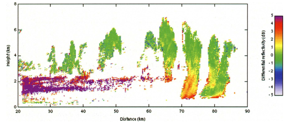
Figure 1: A distance/height scan from the high-resolution 3 GHz Chilbolton radar, showing differential reflectivity (ZDR); the red/purple out to around 60 km shows a stably stratified layer up to about 2 km. Above this are convective towers initiating away from the surface, eventually (70 km on) precipitating to the surface and destroying the stable layer. From Browning et al., 2007.
Deep convective clouds, such as those associated with thunderstorms, are responsible for the heaviest rain as well as strong winds, downdraughts and other high-impact weather. They are often generated as air near the ground is warmed by solar heating. However, sometimes they occur in air separated from the ground by several kilometres. Such elevated convection can occur day or night and can result in the most severe thunderstorms and flash flooding. However, even our most advanced Numerical Weather Prediction (NWP) systems struggle to forecast elevated convection well. Poor representation of elevated convection is rated the second most important forecast problem the Met Office in the UK and is a major priority area for international Met Office partners.
While the basic environmental characteristics favouring elevated convection are known, at least in some cases, the mechanisms leading to triggering are poorly understood, and, prior to 2023, there has been little observational work apart from ad hoc studies and one relatively recent US field campaign. Poor predictability may arise because local (elevated) variations in, e.g., convergence or humidity that cause initiation are harder to constrain in numerical models than those in layers close to the ground which are directly influenced by surface topography. It is also possible that models have systematic errors that are important for these clouds.
During summer 2023 a major field campaign (WesCon) occurred over the western central UK aimed at studying deep convective clouds; the starting point of this PhD project will be analysis of data collected from radar, satellites and in-situ meteorological research aircraft, together with simulations from state-of-the-art ensemble weather forecast systems. Many situations were observed, including cases involving elevated convection. The objective of this PhD project is to understand deficiencies in the representation of elevated convection in km-scale models that have high enough resolution to represent convection explicitly, such as the Met Office’s deterministic and ensemble high-resolution systems (UKV and MOGREPS-UK, respectively). The ensemble forecast system, in which many perturbed versions of the flow are generated, will then be used with techniques such as ensemble sensitivity analysis and spatial ensemble spread techniques to help deduce the nature of the predictability of elevated convection given particular environmental conditions. The research can also be extended to elevated convection events in other regions of the world, particularly where the Met Office runs convection-permitting forecasts. This includes the USA, where the model is run for the NOAA Hazardous Weather Testbed, or over India or China, where it is run for the Climate Science for Service Partnership programmes.
Lower-resolution weather forecasting and climate models cannot resolve convective clouds – the clouds are smaller than the numerical grid. Their effects on resolved scales have to be estimated using ‘parametrization’ schemes. The Met Office is developing a new parametrization scheme called CoMorph, that has many improvements over its predecessors. However, poor representation of elevated convection is also a major deficiency in the performance of the new parametrization. It is anticipated that the new understanding that arises from this project will therefore have broader impact through improving these models.
Training Opportunities
The student will:
- Work with experts in Reading and the Met Office.
- Spend 3 months working within Met Office HQ with operational meteorologists (mentored by one of the Deputy Chief Meteorologists).
- Develop considerable understanding of NWP systems.
- Develop analysis skills using large datasets to gain insight into fundamental physical processes.
- Gain understanding of the predictability of hazardous weather and the practical application of forecasts and, through extended visits to the Met Office HQ, their customer applications.
- Develop communication skills with knowledgeable users through interaction with operational meteorologists and across the Parachute project.
- Develop software skills in Python and FORTRAN.
Student Profile
This project would be suitable for students with a degree in physics, mathematics or a closely related environmental or physical science. Students with no meteorological background are expected to undertake relevant training within the University of Reading meteorology MSc programmes.
Funding Particulars
This project has CASE support from the Met Office.
References
https://www.metoffice.gov.uk/research/foundation/observational-studies/wessex-convection-experiment
https://www.itv.com/news/2023-09-25/the-scientists-taking-to-the-skies-to-improve-extreme-weather-forecasting
Keith A. Browning et al, 2007: The Convective Storm Initiation Project. Bull. Amer. Meteor. Soc. 88 (12): 1939–1956.
Clark, P., Roberts, N., Lean, H., Ballard, S. P. and Charlton-Perez, C. (2016) Convection-permitting models: a step-change in rainfall forecasting. Meteorological Applications, 23 (2). pp. 165-181. ISSN 1469-8080 doi: https://doi.org/10.1002/met.1538
Corfidi, S. F., S. J. Corfidi, and D. M. Schultz, 2008: Elevated Convection and Castellanus: Ambiguities, Significance, and Questions. Wea. Forecasting, 23, 1280–1303, https://doi.org/10.1175/2008WAF2222118.1