FIDUCEO Vision
It is taken for granted that complex modern societies need and exploit high-quality environmental information to understand and manage the significant challenges and opportunities of large-scale change. This requirement is well-established, and underlies major public investments in the Earth Explorer missions of the European Space Agency (ESA), the EU Copernicus space programme (which will sustain and expand many Earth Explorer mission capabilities over future decades), the established and emerging Copernicus services, major programmes to preserve historical Earth Observations and (re-)exploit them for climate applications, not to mention sustained investments in meteorological satellites and services.
FIDUCEO’s ambition was to develop a widely applicable metrology of Earth Observation (EO), since we see the metrological approach as the most fruitful means to establish traceable, uncertainty-quantified evidence for climate and environmental change from space assets. Metrology brings hard-won rigour and clarity to EO, which is intrinsically a measurement science.
The core contribution is therefore in establishing the trustworthiness of climate and environmental information from space assets, so that scientists and decision makers can draw conclusions understanding the strengths and limitations of that information.
Technically, trustworthiness implies that the degree of uncertainty inherent in all data/information is quantified (on the scales of space and time relevant to a particular application). All data and associated uncertainty estimates need to be traceable, which means that, when necessary, the values are justified, reproducible and defensible.
Different users need information on a range of levels of processing, with decision makers typically interested in high-level information and indices, while technical and scientific applications may engage with lower-level data (e.g., ‘level 2’[1] data).
The idealised chain of information flow from raw satellite measurements to climate information, is illustrated Figure 2‑1.

Figure 2‑1. Idealised flow of information from raw satellite data to high-level climate information informing real-world applications. At lower levels, questions about data are often scientific. At higher levels, questions about data more often have implications for decisions, risk assessments and liability. Two pertinent questions are “How certain is this information?” (which is addressed by the metrological concept of uncertainty—i.e., the quantitative degree of doubt to attribute to any number) and “How defensible is the information?” (to which the metrological concept of traceability is relevant).
In each transformation of data to higher levels, the uncertainty present at the lower level causes uncertainty in the higher-level results (propagation) and assumptions, auxiliary data and computations used in the transformation contribute new sources of uncertainty[2].
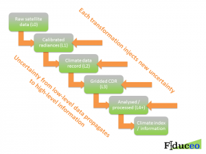
Figure 2‑2. Accumulation of sources of uncertainty and propagation of uncertainty from lower-level to higher-level data.
This context is sufficient to explain the role of FIDUCEO and of Earth Observation metrology within a larger aspiration: in order to deliver trustworthiness of climate (and other environmental) information from space assets, the accumulation of sources of uncertainty and propagation of uncertainty from lower-level to higher-level data needs to be understood and the outcomes usefully (simply) communicated to users.
Normal good practice should evolve towards:
- space agencies developing rigorous, validated FCDR-level uncertainty information as a routine part of mission development and dissemination of their satellite observations—historic, current and future
- scientists (in space agencies and elsewhere) exploiting FCDR information metrologically to provide uncertainty estimates in climate (CDR) and environmental products at higher levels and across all spatio-temporal scales relevant to applications
- users of CDRs etc. trusting and exploiting the incorporated uncertainty information when testing models, creating climate indices, etc.
- decision makers and non-expert users being informed about the uncertainty in climate information in understandable ways, and having high levels of trust in their data and its uncertainty based on traceability
Success across the ever-increasing number of missions will require a continuous interaction of scientific and operational institutions to achieve these goals. Already, FIDUCEO partners are exemplifying this interaction in projects for the Copernicus Climate Change Service. Adopting and extending the language and analytical approach of metrology brings conceptual clarity, rigour and practical techniques to this enterprise, and also leads to improved quality data records and climate information.
[1] Level 2 (“L2”) products are directly obtained by inference from FCDRs (which are L1). In L3 products, data are aggregated onto grids for convenience. L4 products address the needs of some users for data that are complete in space and time, by infilling gaps in L3 data with interpolated estimates for unobserved places and times. Higher-level data typically further process lower-level data, perhaps combining with other information sources, deriving indices etc. While this sequential account is conceptually valid, in practice, there are many variants—e.g., an L4 analysis may derive from L2 inputs bypassing L3.
[2] Note that some transformations, including averaging of data to larger scales, also reduce the magnitude of some components of uncertainty, so despite the accumulation of sources of uncertainty all through the chain, it is not inevitable that in the higher level information the uncertainty is large. Note also that some sources of uncertainty that are negligible in lower levels can dominate uncertainty in higher levels, understanding of which involves the nature of correlated errors.