Radiosondes – providing an independent verification of satellite data
Posted on
by David Moore and Tim Trent
Since the late 17th century, instruments have been developed to automatically record metrological data. As technology has advanced the methods used have also become increasingly more sophisticated, e.g. the adoption of radio transmission in the 1920’s [1]. This process led to the development of instruments called radiosondes; devices that are primarily used to collect temperature, pressure and humidity data from high altitude balloon flights. Modern radiosondes also carry GPS allowing for accurate position and wind velocity data to be taken. From 1939 the ‘Kew’ Met Office sonde was the first successfully used radiosonde used in the UK. These were replaced by the Mk2 in 1945, which operated in to the 1960s [2]. Since then, generations of increasingly accurate radiosondes have taken their place with the most recent being the Vaisala RS92 family.
For several decades radiosondes have been the primary means of obtaining high resolution vertical profile data between the surface and the upper troposphere lower stratosphere region for use in meteorological forecasts. More recently, radiosondes have been used for the validation of satellite retrievals and assessment of climate trends from archived data [3].
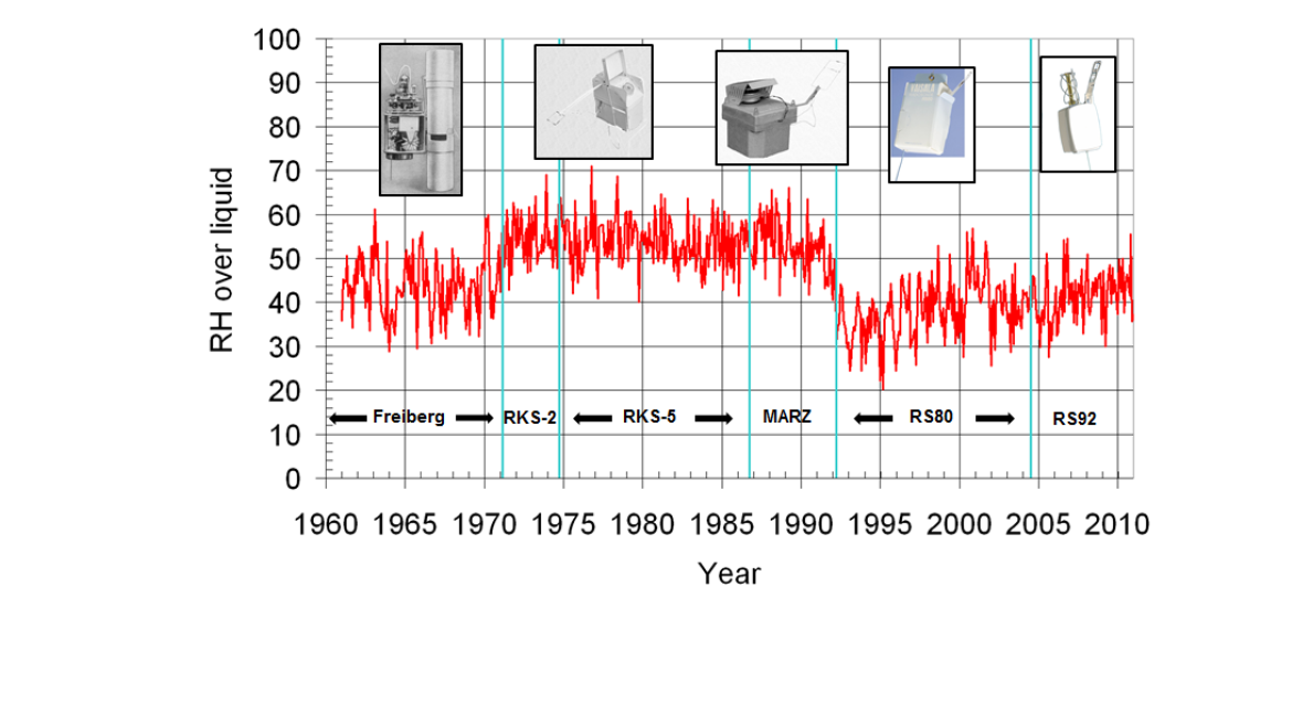
Figure 1. Time series of relative humidity at 8 km over Lindenberg from 1960-2012. Steps due to instrument change are clearly visible and highlight the need for accurate and detailed reporting of these measurements. Image taken from the presentation ‘Results of the measurement strategy of the GCOS Reference Upper Air Network (GRUAN)’, given by Holger Vömel, CIMO TECO 2012.
Characterisation of uncertainties is important when building a time series of reference measurements, as traceability is paramount. Coupled to this, changes in instrumentation make it difficult to resolve any trends as they can introduce step functions within the time series. Figure 1 clearly demonstrates this effect over Lindenberg in a time series that spans over 50 years (1960-2012). The changes in operational radiosondes introduce clear steps in the signal above the site. Where radiosonde observations have been made for numerical weather prediction, the instrumental uncertainties have not been characterised and systematic errors have been disregarded [4].
The GCOS Reference upper-air network (GRUAN) aims to provide fundamental guidelines for establishing and maintaining reference-quality atmospheric observations which are based on principal concepts of metrology, in particular, traceability, Figure 2.
Figure 2. The distribution of GRUAN sites (as of May 2015). Sites with certified RS92 radiosonde programs are shown in red, while sites in the process of being certified, or awaiting certification, are shown in blue. Image taken from (http://www.dwd.de/EN/research/international_programme/gruan/sites.html)
GRUAN soundings are characterised with reference to a `truth’ which is described in [5]. With temperature soundings, lab measurements of solar radiation effects at differing pressures, insolation and ventilation scenarios are used to correct the raw data. Humidity measurements are corrected for time-lag and solar radiation dry bias.
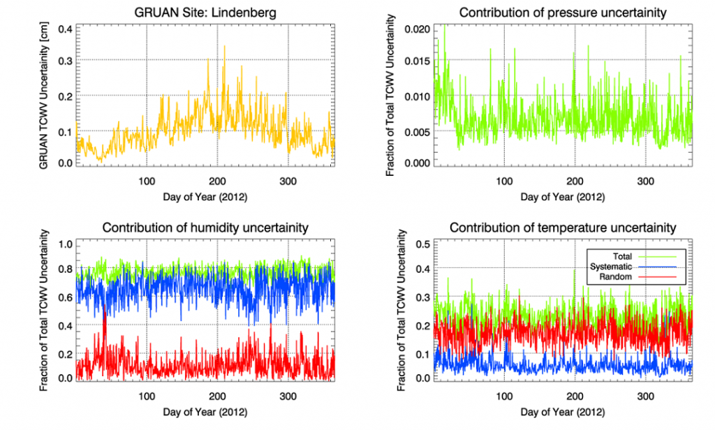
Corrected GRUAN profiles are also accompanied with their respective uncertainty analyses which are divided into correlated (systematic) and uncorrelated (random) components. The systematic uncertainties arising from calibration are generally correlated over, either the entire signal range, or at a range greater than that of the vertical time resolution. The random component is calculated as the uncertainty of the mean and is dependent on the smoothing filter used [5]. At most GRUAN sites the systematic error on the specific humidity dominates the total error in the total column water vapour and varies by a factor of 5 over the course of a year at the Lindenberg site, Figure 3.
Figure 3. Variability of the GRUAN radiosonde uncertainties at the Lindenberg site during 2012. Reported errors are split into systematic and random components [4].
Previous studies such as [6] have attempted to compare radiative transfer model calculated radiances to satellite observations from IASI to determine biases. It was concluded that the work required sonde measurements with an exceptionally low bias in absolute terms are needed (<0.2%). In FIDUCEO, we will perform a series of radiance closure experiments with GRUAN radiosonde data to assess the inter-relationship of IASI, AVHRR, HIRS and AATSR radiances, pre-Envisat failure in April 2012, and continuing into the gap period between AATSR and SLSTR with the aim of evaluating the loss of AATSR in the data record and the success of the gap filled fundamental climate data record. The use of AIRS will provide an independent verification source to the IASI, AVHRR and HIRS radiances.
References:
[1] L. DuBois, R.P. Multhauf, C. A. Ziegler, The Invention and Development of the Radiosonde, with a Catalog of Upper Atmospheric Telemetering Probes in the National Museum of American History, Smithsonian Institution, Smithsonian Institution Press, 2002
[2] Handbook of Meteorological Instruments (Part 2: Instruments for upper air observations), HMSO, 1961
[3] SPARC Assessment of Upper Tropospheric and Stratospheric Water Vapour (2000), D. Kley, J.M. Russell III, C. Philips, Stratospheric Processes And their Role in the Climate (SPARC) , WCRP-113,WMO/TD-No.1043, SPARC Report No.2
[4] Trent, T. J. (2015). Climate and variability of water vapour in the troposphere(Doctoral dissertation, Department of Physics and Astronomy).
[5] Immler, F. J., and M. Sommer, 2011: Brief description of the RS92 GRUAN data product (RS92-GDP). GRUAN Tech. Document GRUAN-TD-4, 17 pp. [Available online]
[6] Calbet et al., Matching radiative transfer models and radiosonde data from the EPS/Metop Sodankylä campaign to IASI measurements, Atmos. Meas. Tech., 4, 1177-1189, 2011