by Rhona Phipps, Bethan Perkins, Anna Mikalsen, Peter Thorne
www.gaia-clim.eu www.fiduceo.eu
On Wednesday the 9th of February, ECMWF hosted a joint meeting between the H2020-funded projects GAIA-CLIM and FIDUCEO to discuss synergies and explore potential opportunities to collaborate further.
The two projects were proposed independently, however both address a fundamental need to improve the characterisation and understanding of uncertainties in Earth Observation measurements where:
- FIDUCEO focuses on spaceborne measurements of radiances, and
- GAIA-CLIM focuses on non-satellite measurements.
The meeting covered areas of overlap and identified potential joint activities to improve the impact and reach of the project outcomes.
Consequently, a key component to the day was the interaction with Copernicus services and how the findings from both projects could be carried forward into the Copernicus Climate Change Service.
Understanding co-locations and matchups:
One of the key topics highlighted by the joint meeting was the common challenges that both projects tackle – for example, the uncertainty inherent in comparing sets of measurements from different sources.
To evaluate the uncertainty estimate, a typical approach is to compare measurements made by different instruments measuring the same variable at the same place and time.
The differences between these instruments and the way in which they measure, however, gives rise to further uncertainties – called co-location uncertainties – which must be properly treated and accounted for.
Researchers in GAIA-CLIM have encountered these when, for example, a lidar measurement is compared to a satellite measurement of temperature (or water vapour or aerosol) to characterise the lidar, the satellite, or both (Fig 1).
FIDUCEO encounters and must deal with these co-location uncertainties when comparing two different satellite measurements, e.g., IASI and AVHRR to quantify uncertainties on AVHRR.
GAIA-CLIM are pioneering the use of a Virtual Observatory facility to quantify non-satellite – satellite co-location uncertainties. FIDUCEO are using a newly developed multi-sensor matchup system for satellite measurement co-locations and cross-sensor harmonisation that will account for co-location uncertainties.
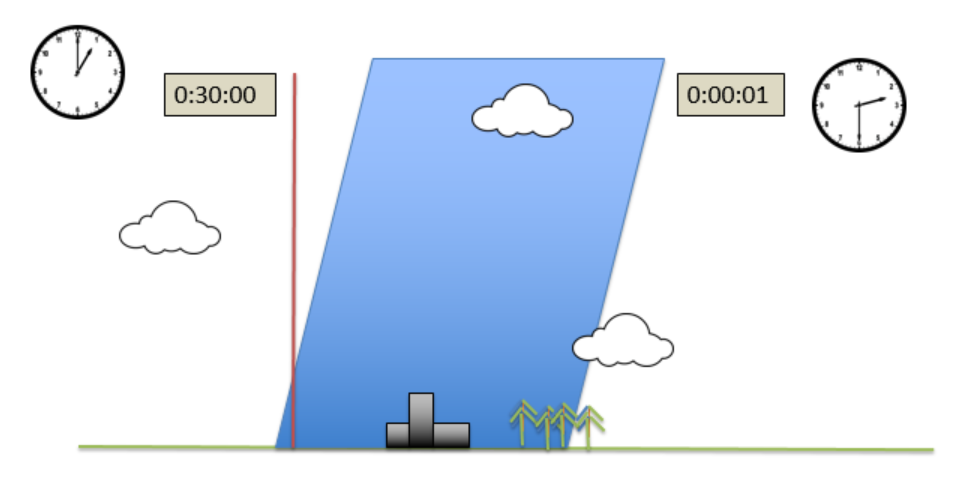
Figure 1 Co-location uncertainties arise when two different measurements of the same thing (e.g. lidar, red vertical beam and satellite-based) are compared to each other. The mechanisms used to make the measurement, the footprint and the timing of the measurement all carry their own uncertainties which propogate into the uncertainty on the measurement itself.
Metrological understanding:
Another common area that the two projects are pursuing is the metrological approach to properly quantify uncertainties. Collaboration and sharing lessons learnt between the two projects here has been invaluable and the combined work of the two projects is driving the evolution of the standard methods of the future.
With expert advice from the National Physical Laboratory, partners in both projects have developed specific characterisation of the measurement uncertainties.
Although both teams use different descriptions of the uncertainties, the underlying metrological principles are the same – ie, from the Guide to Uncertainty in Measurement.
Synergies in CDRs
In addition to these two – and other similar – common research areas, both FIDUCEO and GAIA-CLIM are working together towards the production of long-term datasets of stratospheric water vapour and aerosol. From the outset, FIDUCEO proposed to produce these two measurements as Climate Data Records (CDRs) and GAIA-CLIM is working with measurements of these parameters, derived from the GRUAN network of radiosondes and lidar, respectively. In the coming months, partners from GAIA-CLIM and FIDUCEO will work together on these products, adopting a rigorous metrological treatment of uncertainties. In the meeting, the conceptual framework behind these two collaborations was presented and breakout sessions were held to discuss plans and put together a work plan.
The breakout sessions were a valuable opportunity to discuss the earlier topics and expand on the areas of how to interact further and share ideas between the two projects.
The day was important, strategically, in terms of the timing between the two project schedules and in bringing together both project’s core scientists. It was also an advantage to be able to hold the joint day at ECMWF to reach out to C3S colleagues and highlight our research aims to the NWP teams.
We thank ECMWF for hosting us and we look forward to continuing to share our research outputs and maximising impacts to the Earth Observation community as a whole.