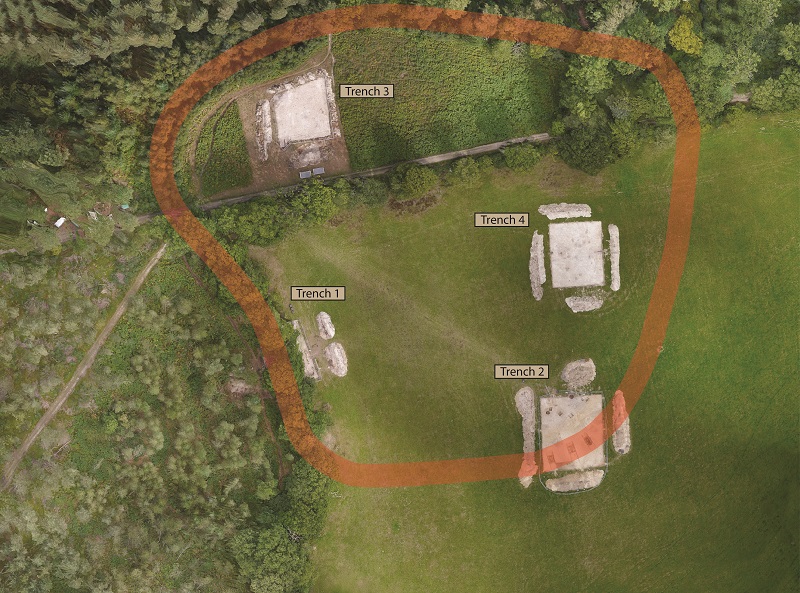
Silchester Environs Project


The Silchester Environs Project is a five-year research undertaking by the University of Reading. It seeks to explore the later prehistoric use of the c.140km2 landscape around Silchester Roman Town and its underlying Late Iron Age oppidum. The project team is aiming to provide a context for the origins of the town and for changes that occurred during the transition to Roman urbanised living through examining settlement, agricultural activity, and landscape in the wider area. We have a focus on the 1st millennium BC but are also interested in the evolution of the Silchester landscape over a much longer timescale. So far, our surveys have added greatly to our understanding of the layout of sites from the Neolithic right the way through to WWII.
The starting point has been a large-area, desk-based assessment, incorporating Historic Environment Records, Portable Antiquity Scheme data, geological, topographic and OS mapping data into a project-wide geographical information system. Aerial photographs, both historic and modern, and lidar imagery have been systematically examined for the whole study area by Krysia Truscoe, adding an astonishing 671 new archaeological sites to the 267 already known. A summary of her findings is given here.
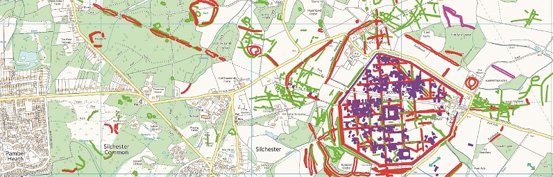
We have further investigated a selection of sites using fluxgate gradiometer, resistance and ground-penetrating radar geophysical surveys (with >95ha of coverage achieved so far), walkover reconnaissance, earthwork surveys and coring exercises. A small number are being studied through excavation, we have already completed several seasons of digging, as described below. After each dig comes the longer process of analysing the site finds and environmental remains, see our Science at Silchester page for more details.
Who are we?
We are a research led team, led by Professor Mike Fulford with co-director Dr Catherine Barnett. You can see a full list of our team here: Who Are We?
A large number of other specialists are called on as and when required, reflecting the wide-ranging nature of the investigations. The majority are based at the University of Reading but a substantial contribution of aerial, earthwork and geophysical expertise has been made by Historic England, for which we are very grateful. The opportunity to work in close partnership with them and in consultation with the West Berkshire and Hampshire archaeological services has greatly benefitted the project and ensures that we are engaging with wider matters such as local and national planning policy, designation and feeding knowledge across the sectors.
The Sites
2018
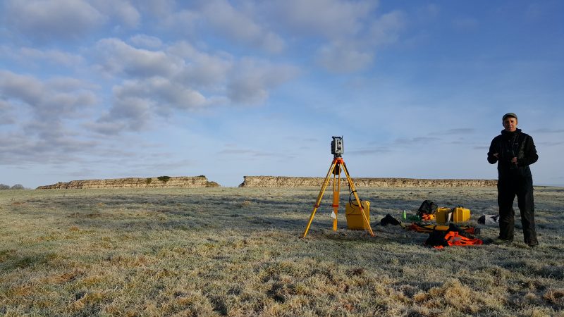
Excavations during 2018 have been dominated by our work at the Bath house at Silchester but prospection has also been undertaken at the impressive earthworks at Rampier Copse to the southwest of the town, described below.
Rampier Copse 2018
The now discontinuous outer earthworks of the oppidum are clearly visible to the southwest of the site, rising up to 5m high with a wide ditch to the outer edge. Detailed Level 3 earthwork survey by the Environs team with Historic England has showed this to be multi-phase and to potentially incorporate and build upon an earlier enclosure, of a similar scale to the hillfort at Pond Farm. A long linear bank and ditch monument, one of the Silchester Dykes, which appears to continue to the Late Iron Age section found at Wood Farm, postdates this enclosure but has a close physical relationship to its modification. Plans to further investigate the complex are currently being moulded.
2017
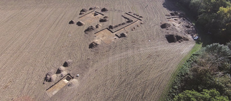
Enclosures at Simm’s Copse autumn 2017
Two circular monuments were identified through interpretation of aerial photography by Cornwall Archaeological Unit and Dr Richard Massey, within arable land adjacent to Simm’s Copse, Mortimer, with further elements added by Krystyna Truscoe for the Silchester Environs aerial mapping survey. The Iron Age settlement and funerary enclosure at Windabout Copse excavated by the team in 2016 lies approximately 800m to the southeast and the barrow cemetery at Holden’s Firs 600m to the north, together forming a late prehistoric landscape complex.
Geophysical survey at Simm’s by our partners at Historic England, using Caesium Vapour Magnetometer and Ground Penetrating Radar systems, suggested the presence of further monuments to the south. A series of ten evaluation-style trenches were opened across the area in October 2017. Excavation of the best-preserved monument (Enclosure 1, total enclosed area 3500m²) revealed the south-western entranceway had a funnel-like form, such as those seen for Late Iron Age banjo enclosures on the Lambourn Downs. Radiocarbon dating is underway for the site but the likelihood of phasing indicated for the excavated gatehouse in Enclosure 1 indicates reuse and rebuilding, hinting at longevity for this site, perhaps it was repeatedly revisited, on a seasonal or longer-term basis.
Our thanks go to the Calleva Foundation for their generous continuing support, also to the Englefield Estate and the Strang family for their help and allowing us access to the site. Please also see our interim report page for more information about the excavations at Simm’s copse
Pamber Forest Middle Iron Age Woodland Enclosures Spring 2017
Interpretation of Lidar imagery for Pamber Forest and walkover reconnaissance allowed us to pick out six previously unknown prehistoric monuments hidden among the trees. In addition to a small barrow, five circular and D-shaped enclosures have been defined, some better preserved than others. A decision was made to evaluate three of these with trenching in order to date and characterise them The largest, a D-shaped enclosure proved to surround a late prehistoric settlement complete with ring gully and also Mid-Late Roman charcoal-making features with related management of oak stands in the area. Pottery was plentiful and coupled with a radiocarbon dating programme, allows us to confidently define the main phase of enclosure construction and settlement as Middle Iron Age. However, the dates also show the enclosures were sited on areas of earlier use, including Middle Bronze Age burnt mound activity and Early Neolithic flint deposition in treethrows related to early site clearance.
The Pamber sites are within a Site of Special Scientific Interest (SSSI), designated due to the occurrence of ancient coppiced woodland. We have therefore been working closely with the landowners, their tenants the Wildlife Trust and Natural England and hope to be able to support their designation and management practices by providing detailed palaeoecological data for the sites including the prehistoric to Roman woodland structure locally.
Our thanks go to the Calleva Foundation for their generous continuing support, also to the Englefield Estate, the Hampshire Wildlife Trust and Natural England for their help and allowing us access to Pamber Forest. Our 2017 interim report also nicely sums up the findings at Pamber forest
2016
Windabout Copse Summer 2016, an Iron Age Settlement and Mortuary Enclosure
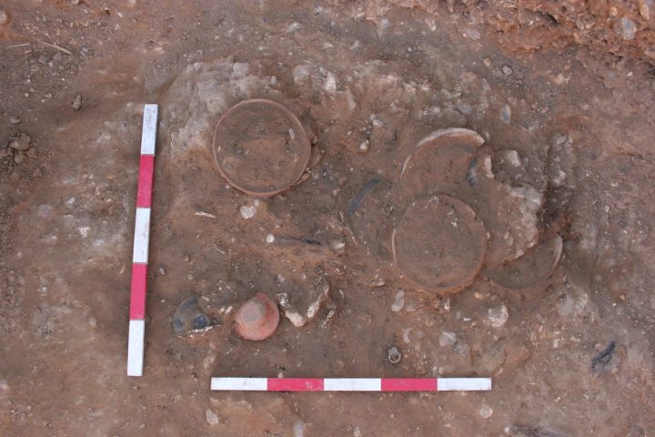
The excavation team headed to Windabout Copse near Mortimer in August and September 2017, in order to assess a series of cropmarks and low earthworks identified during our aerial survey. A series of small evaluation trenches were dug and have revealed remains of exceptional quality and importance. A square anomaly within an enclosure to the north of the complex proved to be a chambered cremation-burial. Burnt bone from the individual was surrounded by pottery vessels: six platters and two drinking cups, Copper-alloy rings found in the fill may have been fittings from a box, which perhaps originally contained the cremated bone. Covering the grave were the remains of several charred planks of oak, perhaps part of the roof of the grave chamber. Four of the pottery vessels in the grave were imported from northern France, the remainder were locally made and all date to the early-to-mid 1st century AD. Close by the grave were large fragments of an imported Spanish wine amphora of similar date, perhaps part of an offering to the deceased. Together,
the grave and its contents suggest an individual of high status with close connections with the late Iron Age centre of Calleva.
This is the first “Stanway type” burial of its kind found in central southern England. Other, comparable burials have been found to the north and east near St Albans and Colchester, and in north Kent, but this tradition of chambered burial originated in the Iron Age of northern France.
The grave and surrounding ditched-enclosure lie in a prominent position on the brow of a hill, and would have been highly visible from the settlement enclosure identified down the hill to the south. A series of ditches there define an enclosed area with some internal partitioning. Preliminary assessment of the artefacts from the ditches indicates initial use in the Early Iron Age, perhaps from about 800BC, with re-use and re-cutting in the Late Iron Age period. A number of features were identified in the small portion of the enclosure excavated. These include a substantial timber-post entranceway with deep pits either side, beam slots with a series of postholes, which define part of a building, and a small, clay-lined oven. Analysis of samples and artefacts recovered during the excavation is ongoing and should confirm the dating and tell us more about this exciting new site.
Although clearly of great interest in its own right, perhaps the true importance of this discovery is that it lies in an area previously perceived as being devoid of late prehistoric activity (despite being close to the oppidum / Late Iron Age Town which underlies the Roman town of Calleva Atrebatum) and that it has been found through the systematic application of non-intrusive prospective techniques. This demonstrates the potential of the wider surroundings to tell us far more about late prehistoric life and landscape in the area than we know at present.
The Silchester Linears, Spring 2016, Iron Age Land Division on a Grand Scale
We tackled several associated sites during April and May 2016, with coring and excavation of three sections of the so-called Silchester Dykes at Pamber Forest, Wood Farm and Brocas Lands. These are part of an irregular network of large linear bank and ditch monument, some of which seemingly lead towards the Iron Age oppidum and overlying Roman town of Silchester, while the relationships of others is less clear. They have not been dated before and are poorly understood, so we set out with the aim of finding just enough organic material to provide a chronology for construction through radiocarbon dating.
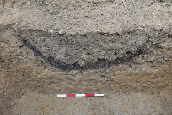
We achieved that and more, with two sites shown to be of later-middle Iron Age date through radiocarbon dating of stratified wood charcoal but we were delighted to find the third, at Wood Farm near Three Ashes, also had associated settlement debris. A deep section across the monument has revealed the monument was constructed during the Late Iron Age in a well-used, agricultural landscape prone to erosion and hillwash with settlement in the immediate area during the early, middle and late Iron Age. The fieldwork team led by Nick Pankhurst and Dan Wheeler recovered samples and a number of artefacts, such as bead rim pot sherds and a spindle whorl made of non-local material (Kimmeridge shale), which were promptly washed clean by the April monsoon rains.
The team would like to express their thanks to Mr and Mrs Oli Lambert, the Englefield Estate, the Benyon Family and the Hodge Family for their interest and kindness in providing access to Brocas Lands, Wood Farm and Windabout Copse. Our thanks too go to the Calleva Foundation for their generous continuing support.
2015
Pond Farm Hillfort, A Multi-phase Defended Site
Pond Farm univallate hillfort lies 1.2km north west of Calleva within Benyon’s Inclosure, Mortimer West End, North Hampshire,. Its close proximity to the oppidum and the likelihood of it having been constructed during the Iron Age was of interest, in particular whether it preceded the oppidum or was in use at the same time and what was the nature of its use. The site had not been excavated or dated previously and so, guided by the results of preliminary earthwork survey of the surviving standing parts of the monument, and geophysical survey on the levelled portion, four 20×20 metre trenches were opened by a team of staff, students and volunteers under the supervision of our project officer Nick Pankhurst. More inaccessible or deep parts of the monument, such as the extant bank and ditch, and on the slope and floodplain below the hilltop, were drilled using a powered auger, allowing 21 sediment sequences of up to 5 metres depth to be recovered as cores.
The site proved to be multi-phased, post-excavation analysis is ongoing but highlights of our findings include:
Evidence for Neolithic Bronze Age and Mid Iron Age Activity and Clearance for Agriculture comes from an old buried soil found by coring at the base of hill , radiocarbon dated to the Later Neolithic at 2890-2660 cal BC (4179+/-26 BP, SUERC-65361). The deposits indicate that, following relative landscape stability under wooded conditions during early prehistory, deforestation and agriculture commenced at the end of the Neolithic or Beaker periods, allowing soil erosion and hillwash down slope during heavy rain events. A burnt out tree throw related to clearance underlying and therefore predating the main monument has proved to be of Late Bronze Age date (780-430 cal BC) with a small pit and another treethrow of Middle Iron Age date (370-170 cal BC: 2213 ± 29, BP SUERC-67562; 2184 ± 29 BP, SUERC-67568) just under the levelled bank indicate continuing low level activity prior to monument construction.
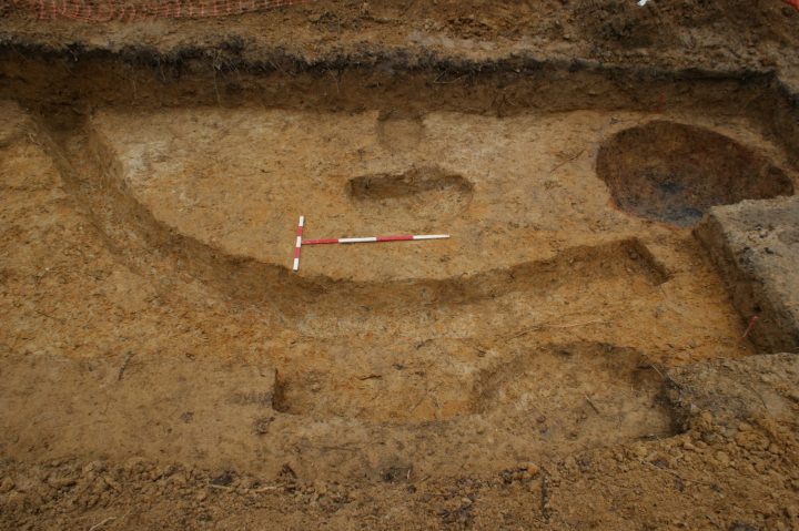
Construction and First Use of the Fortified Monument in the Late Iron Age has been demonstrated. The site was already at least partially cleared and in use by the Iron Age but the construction of the hillfort ditch and rampart would still have been a major undertaking in terms of time and labour. The defences are c.575m long and encircle an area of 2.1ha hectares. Three slots placed through the ditch showed the cut to be up c.6m wide and c.2m in depth. The rampart still rises some 2.5m over the ditch today; coring indicates that local gravel was used to build it up in layers, with each dump compacted before laying the next. Potentially also topped with a fence, the ditch and rampart together would have formed a substantial boundary. Outside the main entrance is a second, smaller length of bank and ditch, clearly shown on the earthwork survey, which seems to have formed a further complex element of the entrance, restricting the size and direction of approach and adding to the impressive nature of the monument.
Although the causewayed entranceway to the hillfort was over 12m wide, access into and out of the monument would probably have been controlled and restricted by a gatehouse or similar wooden structure. Evidence for this was seen beneath the rampart in Trench 1, where a line of dark circles proved to be the remnants of large timbers that formed a palisade across the entrance-way. Charcoal within the foundation cut of the palisade has been radiocarbon dated to the (late) Middle-to-Late Iron Age date at 200-30 cal BC (2083 +/-29 BP, SUERC-65355). The monument was constructed just before or at the same time as the first inception of the oppidum at Calleva.
Sporadic and slight Roman re-use is indicated both by dated recuts to the ditch (eg 230-390 cal AD Mid-Late Roman, 1746 ± 29 BP, SUERC-67570 and above that 320-430 (90.7%) cal AD 1668 ± 29 BP, SUERC-67571 Late Roman) and by a small concentration of late Iron Age/early Roman Silchester ware pottery found within the upper fill of an earlier tree throw hollow close to the entranceway, though birch charcoal from this same fill has been radiocarbon dated to cal AD 240-410 (1710+/-29 BP, SUERC-65356, Late Roman).Overall, however, the scarcity of material culture across the whole site is quite remarkable given the size of monument, with little evidence of any substantial occupation or domestic activity. To the delight of the environmental archaeologists in our team, the main evidence of use comes therefore in the form of plant remains, particularly charcoal but also plant microfossils including pollen.
Interestingly, the earthwork survey by Mark Bowden and team indicates that the defences were never entirely completed. We suspect instead that whatever the original plan during construction, things changed with the establishment and development of the nearby focal point of the oppidum. Thereafter, the monument was probably used for livestock management, clearly repeatedly (and perhaps seasonally) to graze and protect these valuable assets. Whatever their original purpose, the defensive earthworks offered convenient protection of valuable livestock.
Early Medieval Reuse of the Monument was shown by a substantial dump of wood charcoal within a recut of the ditch signifying maintenance of the defences and clearance of secondary re-established tree cover to enable re-use of the monument. The event has been dated to 560-680 cal AD (1377+/-29 BP, SUERC-65360; 1451 ± 29 BP, SUERC-67569), within the Earliest Medieval period. The lack of any associated material culture from this time indicates that it was again probably not used as a settlement but rather for seasonal grazing and agriculture. The entranceway was also modified around this time in the (Late Roman-earliest Medieval period at 263-529 cal AD, 1655 ± 29BP, SUERC-67561). Evidence for this activity is significant as there was previously none for this period in the wider area.
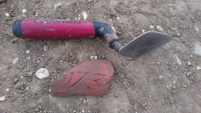
Later again, a charcoal-making feature at the sites has been dated to 1050-1260 cal AD (851 ± 29 BP, SUERC-67563; 831 ± 29 BP, SUERC-67564), while two curvilinear ditches in the north of the trench 2 pointed to further reuse of the area in the post-Medieval period. Both ditches contained a significant number of pieces of peg tile and were potentially contemporary with the use of the tile works near Kiln Pond to the northeast. The enclosure ditch at this point may have still been open and the addition of C-shaped (in plan) ditches could have created a series of agricultural plot or livestock enclosures. The find of a piece of inscribed roof tile in the top of the ditch displaying the date 1734 is an unusually helpful one in picking out more recent use of the site!
Our thanks to the Calleva Foundation and also the Englefield Estate and Dr Richard Massey who were generous with their help, time and access to Pond Farm.
Further Updates on the project can be found on the blog, Silchester Facebook or Twitter. The Silchester Environs project findings,including the case study sites will be published as a monograph series, due out from 2019 but in the meantime, check out our annual interim reports